 WEST
WEST
(July 22, 1980-May 1, 2003)
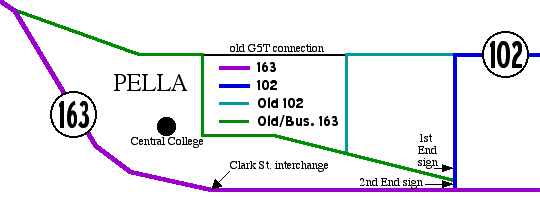
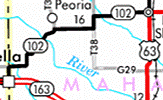
If you look at the 1981 map, and only that map, 102's line goes directly west into Pella, on the line marked "old G5T connection" above. Topographic maps also drew a red highway line straight west. It wasn't until the release of internal DOT documents that we learned for sure that 102 never ended downtown, but at the end of the "Old 102" line shown on the map. (Map 1/26/03)
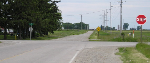
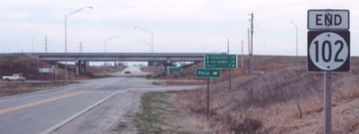
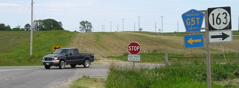
Old WEST End (July 22, 1980-April 5, 1996): Stop sign, IA 163, Marion County
Facing south, but heading west, on 102 (now unnumbered county road) (5/31/05)
Although it looks like a logical route for the state highway system, 102 only lasted 23 years, commissioned during one purge and decommissioned in another. By 1986, 102 ended east of Pella at this stop sign. The gravel road now goes to a dead end, because no bridge was built over the new 163.
Facing north, but heading east, on 102 (4/14/02)
Photo by Jason Hancock
After one north-south mile, 102 turns east, rejoining the straight road that goes into Pella.
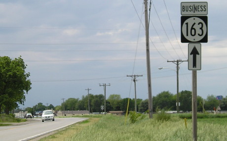
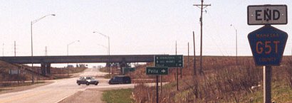
Facing west on 163 (5/31/05)
Given the DOT's tendency to leave signs around (see old IA 46), I bet the straight arrow is a leftover from when it was the junction of 163 and 102; the last sign assembly would be between here and the intersection. The "Business" was added after the bypass was finished.
WEST End: Interchange, IA 163, Marion/Mahaska county line
Dates of photos noted for comparison of views when needed.
Facing south, but heading west, on 102 (4/14/02)
Photo by Jason Hancock
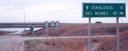
This picture is before the junction with Business 163, the first road behind the LGS (see map at top of page). The onramp for current 163 west is the second, across from the white pickup.
Facing south, but heading west, on 102 (4/4/04)
Photo by Jason Hancock
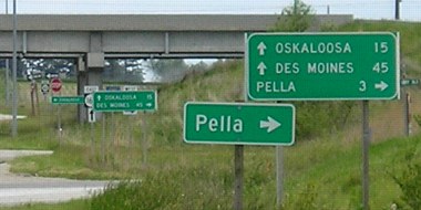
Closeup of the LGSs (5/31/05)
The separate (mixed-case) "Pella" is redundant, as it is for Business 163, and the sign behind it is too. (The LGS for westbound 163 is the next one back.)
Facing east on Business 163 (3/13/03)
Photo by Jason Hancock
Facng east on Business 163 (5/31/05)
The old alignment of 163 was straight ahead, and you can see the ground sculpted as such. This was removed in freeway construction. Take a right and you will see the sign below.
Next LGS at interchange (4/14/02)
Photo by Jason Hancock
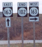
Last 102 sign (4/14/02 and 4/4/04)
Photo by Jason Hancock
Compare the font for the 102 with the first "End" sign. Also compare the fonts for the two 163 signs in this picture. Can we get some standards here, please? As a final bit of strangeness, the shields do not have thin white borders. These shields show up on 163 itself in the Pella area.
Facing north on 250th Avenue/Adams Avenue (6/28/03)
Photo by Jason Hancock
To the left is Marion County. To the right is Mahaska County. Ahead is 102/G5T. In the center is a G5T shield sloppily placed over a 102 shield. At right is the hard work of the Department of Redundancy Department.
The Knoxville Journal-Express reported on August 19, 2004, that the Marion County Board of Supervisors "transferred the jurisdiction for a portion of 250th Avenue to Mahaska County." The mile of 102 to the north of here follows 250th Avenue, so it's possible that Marion County was originally in charge of 102's last mile despite the presence of only Mahaska-labeled county road signs. (At the same meeting, the board approved the contract to tear down the bridge for old IA 92 near Tracy.)
Facing north on 250th Avenue/Adams Avenue (11/15/13)
This interchange has an odd issue with losing county road pentagons; see below. The wear and tear on the left set probably has to do with the fact these are on a gravel road.
Facing north on 250th Avenue/Adams Avenue, about to become 102 (5/31/05)
Closeup of signs in above picture (5/31/05)
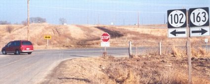
Facing north, but heading east, on 102 (3/13/03)
Photo by Jason Hancock
A left turn puts you on Business 163.
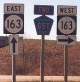
Facing north, but heading east, on G5T/102 (6/28/03)
Photo by Jason Hancock
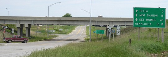
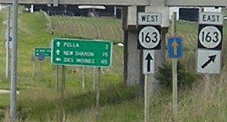
Signs like this also were placed at the ends of IA 223 after it was decommissioned; ditto IA 225. North and east of here for about five miles, new concrete serves an area that is becoming quasi-suburban - too many (and too expensive) houses to be farmland, but neither incorporated nor city-dense. Outside of there, the road maintains a county road feel, perhaps because all of the concrete was (as of 2003) original county concrete from 1962 and 1967.
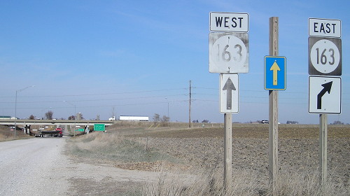
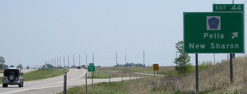
Facing east on 163 (4/14/02)
Photo by Jason Hancock
Someone's getting lazy with the new signs. Many very recent BGSs - see also IA 1 and 64 at US 151 - don't have directional tags added above the shields. In addition (or lack thereof), there's no signage for Business 163 either. In a twist from other business routes, Business 163 is signed both ways on one end (west) while in neither direction at the other. (OK, technically Business 163 may not get back to its parent at the east end. But it's pretty darn close.)
Facing east on 163 (5/10/05)
Facing east on 163 (5/10/05)
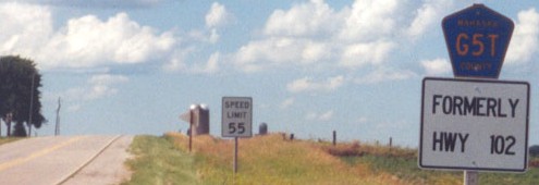
While the 102 shields on the BGSs stayed up longer than on the route, G5T shields did replace them. I hope other decommissioned routes receive the same treatment on BGSs, but so far this has not happened much elsewhere.
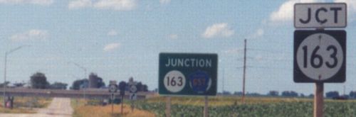
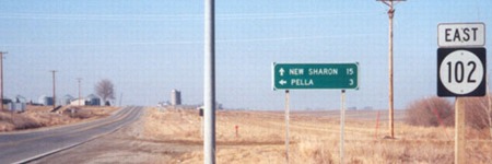
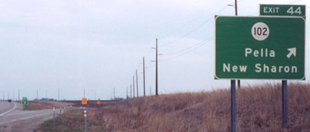
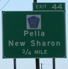
The east end for 102 was with IA 146 at US 63 in New Sharon. Both ends are on the same page.
Last seen: 2003
Page created 5/29/02; last updated 3/28/17