
(July 1, 1920-September 4, 1941)
- In 1920, they knew it as: Nothing uniform, although parts followed Pershing Highway, Southwest Trails, Diagonal Trail, and a trail sponsored by the Center Point Motor Club (9 counties)
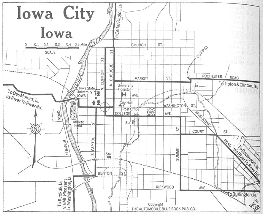
- We know it as: W20, IA 1, the roads as shown on Jason Hancock's Highways of Iowa City and Highways of Cedar Rapids pages with old old US 218 in between, Center Point Road, old IA 920, IA 150, and US 52
- Let's get granular:
- Mount Sterling to Washington: W20, IA 1, H17, W21, IA 1, IA 92
- Washington: IA 92/Madison Street, Avenue D, Washington Street, Marion Avenue
- I made a guess on this route in Washington, rather than the present route of IA 92 and a known previous routing of IA 1 (Madison Street and 2nd Avenue), on two separate hunches: That the first alignment of the east-west road would not run two blocks south of the town square, and the former gas station at the corner of IA 92 and Avenue D looks like a clue; and that the diagonal on the north side of Washington, labeled "Old Hwy 1", did not exist until later. This concrete remains there today, given its narrow width and telltale sign of a shaved curb. My guess was confirmed through newspaper research in early 2022.
- From late 1926 to early 1939, IA 1 and IA 2 intersected in downtown Washington.
- Washington to Iowa City: 230th Street, Nutmeg Avenue, 180th St, IA 1, 140th Street, Locust Avenue, IA 1, 540th St, W62/Sharon Center Road, IA 1
- While it seems like a more natural original alignment would continue north on Nutmeg Avenue through the unincorporated village of Richmond, and then go through Kalona on or near 6th Street (and Maple Avenue/Gable Avenue northward), every available document shows the route above instead.
- The former Nutmeg Avenue crossing of the English River, known as the Bunker Mill Bridge, was closed in 2004, set on fire in 2013, in danger of being lost in 2017, and handed over to a preservation group in 2018.
- Iowa City: Miller Avenue, Benton Street, Riverside Drive, Burlington Street, Clinton Street, Washington Street, Dubuque Street
- A 1919 city map uses Benton Street to cross the Iowa River, then come into downtown via Capitol Street. The route could have been relocated to the Burlington Street bridge in 1915 and the map was late, but there's at least one argument for retaining Capitol until the late 1920s: It passed the Johnson County Courthouse.
- Iowa City to south side Cedar Rapids: Dubuque Street, Curtis Bridge Road, Club Road, E70/Wright Brothers Boulevard, Kirkwood Boulevard, a road in the middle of Section 9 that is now the US 30 freeway
- From downtown Iowa City to downtown Cedar Rapids, IA 11 and 40 share the corridor.
- It is possible, perhaps even likely, that before paving in 1927, the route through North Liberty used Zeller and Main streets. That would match the 1914 map, which also had the route on the other side of the railroad north of North Liberty.
- As late as the 1960s, the entire town of North Liberty was contained in a square bordered by the railroad and Penn, Front, and Zeller streets.
- The abandoned road you can see from the northbound lanes of I-380 when Coralville Lake is low is this alignment.
- Just north of Shueyville on the Linn County side of the line is an extinct map dot called Western. The town came into existence in 1856 and was named because it was the westernmost college of the United Brethren Church. The college made it 25 years before relocating because Western was not on a railroad, and was moved to Toledo. It was renamed Leander Clark College, after a benefactor, on January 23, 1906, and then merged with Coe College in 1918, "returning" Western College to Linn County. (Tama County History, 1987; Toledo Chronicle, January 25, 1906).
- Cedar Rapids: J Street, 16th Avenue SW, C Street SW, 1st Street SW, 1st Avenue, College Drive NE, Oakland Avenue NE, 32nd Street NE, Center Point Road
- The 1914 Linn County map has "add'n 10-1-23" south of the then-Cedar Rapids city limits at Wilson Avenue (middle of Section 33). This is confirmed by the Cedar Rapids Gazette in late 1922: "... a new road the rest of the way and entering the city at C street instead of J street as it is at the present time ... The road would join C street at Bowling's hill near the Bohemian National cemetery". (Capitalization styles then were different than today.)
- The connection between J and C streets, 16th Avenue SW, was found in a mid-1924 letter to the Gazette editor from the president of the Red Ball Route association, stating that the association had nothing to do with changing the route. In fact, he was upset "there is a certain group responsible for taking it on themselves to switch the Red Ball route and the markers without authority."
- C Street goes past Cedar Rapids' Czech Village and the intersection with 16th is in its heart.
- College Drive/Oakland Road is now one-way northbound from 1st Avenue to H Avenue.
- Until 1926, 32nd Street NE was the northern city limits of Cedar Rapids, when there was an annexation up to the railroad. Only a fraction of the track is still around, between I-380 and Council Street. However, its ROW has stuck around as the Grant Wood Trail, empty spaces south of Blairs Ferry Road, and IA 100 from I-380 to near Xavier High School.
- Hiawatha to IA 150/920 junction: W6E and D62, with the following exceptions:
- Abandoned piece of County Home Road on the section line and northward extension of Burd Lane at the gas station (County Home Road was realigned for I-380)
- A fraction of Cummings Ford Road and half-section line north
- Fay Road and Logan Lane just southeast of Center Point
- Maiden Street, Main Street, and either Washington or Vine Street in Center Point (the 1930 paving plan doesn't label intersection except as "Pres. #11")
- Heins Road and northward extension
- Mill and Grant streets in Walker, including the gravel road in front of the cemetery
- IA 150/920 junction to West Union: IA 150 except/but including the following:
- Harder curves on the 1-mile shift between Independence and Hazelton, more aligned with 170th Street (before 2013)
- Bryantsburg Boulevard and Fontana Boulevard south of Hazelton
- 110th Street, Issac Avenue and extension north to IA 281, Frederick Avenue in Oelwein
- The alignment along Rock Island Avenue in Oelwein opened October 13, 1986.
- Klock Road, Washington Street, Clark Street, Main Street, and Old Highway 150 in Fayette.
- The Fayette bypass opened July 25, 1962.
- Franklin (IA 56), Vine, Jefferson, and Auburn streets in West Union
- State Street through Eldorado (dead-ends to south; Turkey River bridge exists but is closed)
- 110th Street and 241st Avenue forming a corner south of Festina
- 236th Avenue through Festina, plus the driveway to the quarry on the other side of Brockamp Creek
- West Union to state line: US 52 except/but including the following:
- North Street in Calmar and 240th Avenue north to dead end, bypassed in early 1960s
- 235th Avenue and 210th Street, and Big Timber Road and 222nd Avenue
- A portion of Trout Run Trail starting where 52 turns north
- Short Street, Mechanic Street, Water Street, and College Drive in Decorah
- 211th Avenue, and then 236th Avenue through Burr Oak, both bypassed ca. 1974, probably in the same project that changed the route at the state line
- Related routes (900s except 920 and 965 unsigned):
- IA 1 (II): IA 11 south of Iowa City after 1926, except south of IA 3 (I)/2 (II)
- IA 150 (IV): IA 11 from one mile south of the Benton/Buchanan line to Calmar after 1941
- IA 915 (I): Two blocks of Frederick Avenue north of Charles Street in Oelwein
- IA 916: Some but not all of the rest of Frederick Avenue outside of Oelwein's 1986 city limits to IA 281
- IA 920: Old IA 150 through Walker to Center Point
- IA 921 (I): Old IA 150 in Hiawatha (Center Point Road), later extended to Center Point
- IA 922 (III): Business US 151 in Cedar Rapids (relevant segment: 1st Avenue from 1st Street SW to College Drive/Oakland Road/13th Street SE)
- IA 965 (I): Bypassed segments of US 52 north of Decorah
- IA 990 and IA 991, later renumbered IA 982 (I): Old IA 150 in Fayette
- Overlap with IA 40, but really related to US 161/US 218:
- IA 84 (II), 6th Street SW in Cedar Rapids to near the airport; 218 moved there from Bowling Street in 1953 (north of present US 30) and 1956 (south)
- IA 153 (II), road between Coralville and North Liberty replaced by 218 in 1957
- IA 153 (III), Dubuque Street from downtown North Liberty north to old 218, after the reroute
- IA 965 (II), old 218 between Cedar Rapids and Coralville. This one did get signed.
| IA 11 endpoint history | |||
| FROM | TO | NORTH | SOUTH |
| 7/1/20 | 2/18/24 | Minnesota state line (US 52) | Mount Sterling OR Missouri line |
| 2/18/24 | 3/18/25 | Missouri state line (Old IA 15) | |
| 3/18/25 | 10/16/26 | Calmar (IA 24/150 at US 52) | |
| 10/16/26 | 193X |
US 161 (College Dr at 1st Ave) | |
| 193X | July 1940 |
US 30 (1st Ave at 10th St SE) | |
| July 1940 | 9/4/41 | US 218 (K St at 16th Ave SW) | |
NORTH End (1): Minnesota state line, now near US 52, Winneshiek County IA/Fillmore County MN
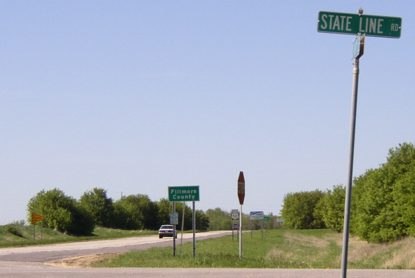
Facing north on 11 (5/19/04)
In 1924, IA 20 replaced IA 11 north of Decorah, in all likelihood to match MN 20. The 1922 Minnesota state map from the Minnesota Digital Library is the oldest online that includes highway numbers. Before 1924, the road came to this point, jogged east, then turned north. That was changed in 1928 to curve a bit east to the state line; in 1974 it was re-realigned to go straight. Unfortunately, aerial photos cut off right at the line, so I can't specify if Prosper was bypassed before the road was straightened at the line.
NORTH End (2): IA 20, now IA 150/IA 24 at US 52, Calmar, Winneshiek County
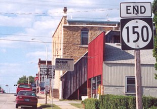
Facing north on 11 (7/14/02)
Photo by Jason Hancock
Many more pictures of this intersection can be seen on the Calmar page.
IA 20, whose northernmost part originally went northwest from Decorah and then north-northeast to the state line, was changed in 1924 presumably to get the result of connecting to MN 20. MN/IA 20 from Cannon Falls to Dubuque became US 53 (unless it didn't), US 55, then US 52; IA 20 from Dubuque to Keokuk became US 61.
This is the present north end of IA 150, which replaced IA 11 in what was possibly a misguided attempt to extend US 150. (US 150 itself, which runs from the Illinois side of the Quad Cities to central Kentucky, is a weird highway, a diagonal route greatly lengthened after a 1934 extension.)
SOUTH End (3): US 161, now College Dr. at 1st Ave., Cedar Rapids, Linn County
This intersection would be IA 11's south end after implementation of the 1926 series. It had two other endpoints in Cedar Rapids over the next 15 years. College Drive is 13th Street as it goes through Coe College and then has a non-intersecting intersection (it's weird) with Center Point Road.
Cedar Rapids is a
commercial pivot of a territory whose population numbers over one
million and a quarter people within a radius of 100 miles; a young city
already strong, not only in its numbers, but in its citizenship; a city
advantageously situated in the garden spot of the Middle West — the envy
of her sister cities as a distributing center; a city which has already
won distinction for commercial and industrial enterprise...
— Huebinger's Map and Guide for Iowa Official Transcontinental
Route (1912)
[It goes on from there, and on, and on. Hyperbole existed long before
the field of public relations. — Ed.]
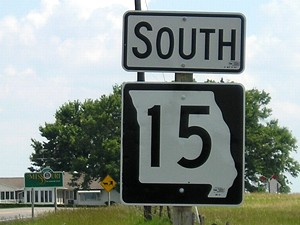
SOUTH End (2): Missouri state line, now V56 at state line, Van Buren County IA/Scotland County MO
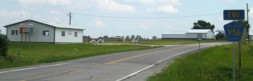
Facing south on 11 (6/11/07)
In early 1924, after months of planning, the IHC moved the southernmost part of IA 11 to connect with the Missouri route coming up from the south. The original intention was for Mount Sterling to remain in the state system, with a new "stub route" IA 113. However, this never got put into effect. Less than four years after the primary system's creation, Mount Sterling became the first Iowa community to permanently lose a connection. It would disincorporate about 90 years later.
Closeup of first sign (6/11/07)
The "Memphis Road" south from Milton to the county seat of Memphis MO has carried the numbers 11, 23, and 15. This was the "south" IA 15 created in the Great Renumbering of 1969.
SOUTH End (1): Mount Sterling OR Missouri state line, Van Buren County IA/Clark County MO
Probably not facing south on 11 (10/3/15)
Mount Sterling is close enough to the state line that it's not possible to tell if IA 11 ended there or here. The only hint is that the 1914 county map says the mile south of Mount Sterling was added in 1926, making the end north of this picture. The Waubonsie Trail went from Cantril to Mount Sterling on gravel J56, then went into Missouri on what's now Route V, before turning north to Farmington on MO/IA 81. (Had the Sullivan Line been drawn straight, it all would have been in Iowa.) That wouldn't have worked for a highway across the southern tier of Iowa, and thus IA 3 ran to the north.
The road curves to follow the Clark/Schuyler county line in Missouri.
Page created 5/10/20; last updated 4/25/22