
WEST Iowa line: Missouri River (with I-480), Council Bluffs IA/Omaha NE, Pottawattamie County IA/Douglas County NE
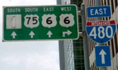
Facing south on 14th Street in Omaha (old SB US 73) at Dodge Street (6/16/03)
This sign, up in 2003 but gone in 2006, still shows the early 1980s configuration of highways in downtown Omaha. The covered-up space at far left is US 73. All the highways were on one-way pairs here, so a right turn would be for westbound 6 on Dodge but eastbound 6 is at the next intersection. (Northbound 73 would be a block to the left.) This sign is gone now, as is the brown building behind the 480 shield (old Union Pacific headquarters).
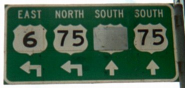
Facing south on 14th Street in Omaha (old SB US 73) at Douglas Street (6/16/03)
Here is where US 75 would have joined US 73 (second from right shield) going south. A left turn onto Douglas would have been going north on 75 and east on 6 to the bridge, but 75 hasn't been on Douglas or 13th/14th for 20 years.
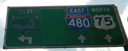
Facing east on Douglas Street at 13th Street (6/16/03)
Reconstruction of I-480 (and thus, closure of the onramp) is probably responsible for the wear and tear on the far left, and the greened-out space probably held "North 73 [up and left]". This sign was still up in early 2008.
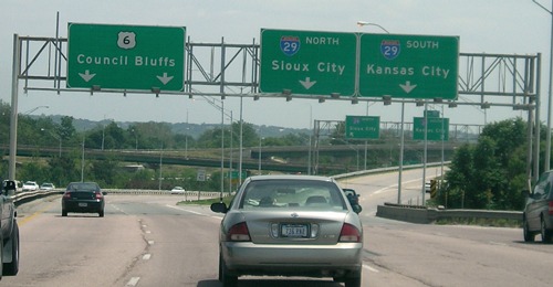
Facing east on 6/Douglas Street (4/6/08)
Just after the light for 10th Street, eastbound 6 heads up to join the I-480 bridge into Iowa, whose signs can already be seen.
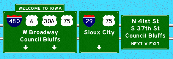
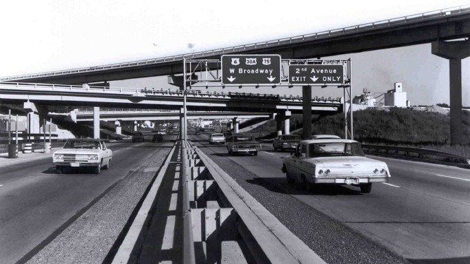
This is a representation (via Kurumi's SignMaker) of I-480's entrance into Iowa as it appeared in the Council Bluffs Nonpareil on Oct. 24, 1968, as I-29 opened north of I-480. (In reality, the arrows on the far left sign were to either side of the text. That "v" is a down arrow.) Notice that 75 is BOTH straight ahead and on 29. Since 480 opened first, Broadway is where 75 used to go, but that shield would have been removed the day after the photo was taken. (Maybe. See the DOT photo below.) The modern version of this assembly, still with the "Welcome to Iowa" across the top, is below.
UPDATE: The day I added I-74 pictures at the bottom, the Iowa Transportation Commission voted to transfer jurisdiction of West Broadway to the city of Council Bluffs. US 6 will be moved onto I-29 and I-80 around the city. When the signs will change, and how permanent they will be, is yet to be seen.
Facing east on 480/6 (6/12/06)
This sign gantry is actually on the Nebraska side of the river. The center lane in this picture is one of the two lanes coming from US 6/Douglas Street; mainline I-480 is coming in on the left.
Facing east on 480/6 (6/12/06)
One interesting thing about this interchange is that there is no access to eastbound 6 from I-29.
Facing east, from the Nebraska side (10/1/16)
The appearance of Exit Zero is a recent development. "Dodge Park" has changed to "Riverfront".
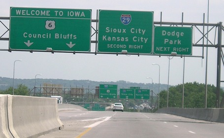
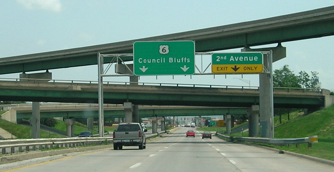
Facing east on 480/6 (6/12/06)
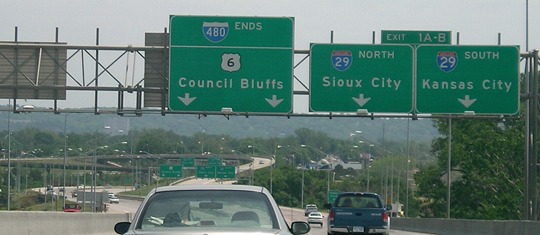
The above pictures encompass the entirety of mainline I-480 in Iowa. When 6 is rerouted, it will leave a gap on the left sign.
Pictures of the interchange from I-29 can be seen on the I-480 page.
Facing east on 480/6
Copyright © Iowa Department of Transportation. All rights reserved.
This picture is from between October 21, 1966, when I-480 opened into Nebraska, and 1969, when US 30A was dropped.
The state has 140 photos of construction of the I-480 bridge, but the website does not allow direct linking. You have to go to this site and click "Accept," but then the I-480 gallery is one of the root galleries.
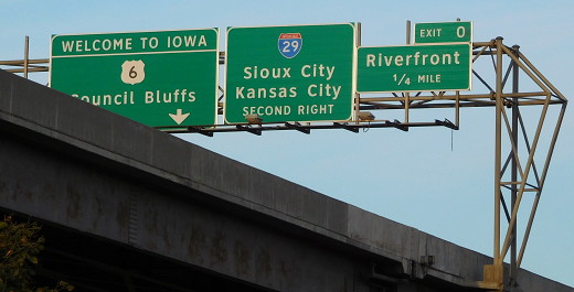
Facing east on 480/6 (6/22/13)
Same gantry and same bridges, 45 years later! (The middle one still retains its railing.)
Facing west on 480/6 (6/12/06)
This is the other side of the "480 ends" or middle gantry. This bridge is the nearest access to/from Carter Lake.
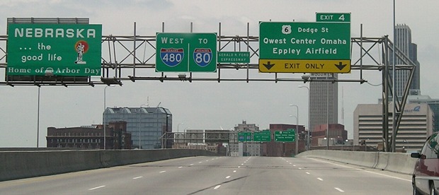
There is now an uncentered, pasted-over line on the Exit 4 gantry that says "Event Ctr-Ballpark" instead of "Qwest Center Omaha."
Old WEST Iowa line: Missouri River (Ak-Sar-Ben Bridge) (with US 75 and US 30A), Council Bluffs IA/Omaha NE, Pottawattamie County IA/Douglas County NE
Highways on the Ak-Sar-Ben (Douglas Street) and I-480 bridges
| 1920-late 1926 |
|
| 1926-late 1931 |     |
| 1931-34 |     |
| 1934-39 |
 |
| 1939-41 |      |
| 1941-60 | |
| 1960-66 | |
| I-480 bridge opened Oct 21, 1966; Ak-Sar-Ben Bridge torn down 1968 | |
| 1966-69 |    |
| 1969-84 | |
| 1984-present | |

 (?)
(?)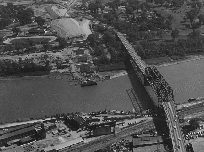
Facing east, Iowa at top (10/4/64)
Copyright © Iowa Department of Transportation. All rights reserved.
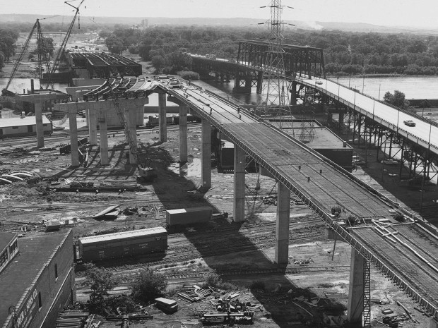
Facing east, view from Nebraska side (7/6/66)
Copyright © Iowa Department of Transportation. All rights reserved.
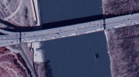
Aerial photo from ortho.gis.iastate.edu
The Ak-Sar-Ben/Douglas Street Bridge, originally built in 1888, was located very near the present I-480 bridge; a pier of the old bridge is still sitting in the river today (lower right).
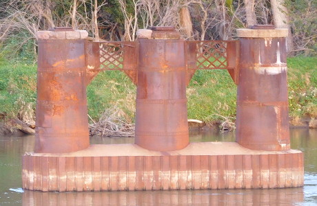
The standing pier, viewed from the Nebraska side (10/1/15)
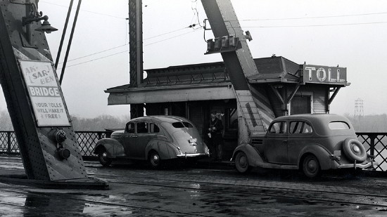
Library of Congress photo (1938)
Tolls were removed from both the Ak-Sar-Ben and South Omaha bridges on September 25, 1947.
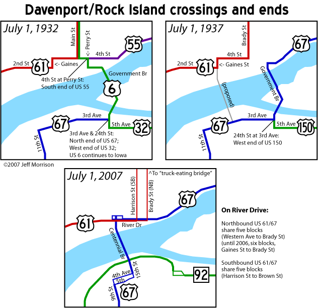
Old EAST Iowa line: Mississippi River (Government Bridge), Davenport IA/Rock Island IL, Scott County IA/Rock Island County IL
Highways on the Government/Arsenal Bridge
| July 1920-October 1926 |   (?) (?) |
| October 1926-December 1931 |  |
| December 1931-December 1934 | |
| December 1934-November 1935 |   |
| November 1935-July 1940 | |
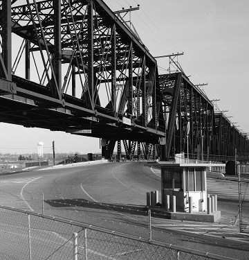
Facing southeast, but heading east, on 6 (February 1985)
Library of Congress photo
In December 1896, a two-level bridge opened connecting Iowa and Illinois via Rock Island (the island). This would be the only connection between Davenport and Rock Island (the city) until 1940, and is the only bridge on either side of Iowa built in the 19th century that lasted into the 21st. (This bridge was the replacement for the first one to ever cross the Mississippi River!) It's interesting that a bridge originally built for carrying railroad traffic and horse-drawn wagons was "replaced" by a bridge that today carries an interstate highway, below.
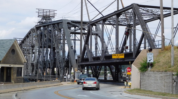
Facing north (9/27/15)
This spot on the west end of Rock Island is the original site of Fort Armstrong. You can see how the cars go under the railroad to cross into Iowa.
For a map showing just the highway history of this bridge crossing, click here. For detailed Davenport highway history, see Jason Hancock's page.
EAST Iowa line: Mississippi River (Iowa-Illinois Memorial Bridge) (with I-74), Bettendorf IA/Moline IL, Scott County IA/Rock Island County IL
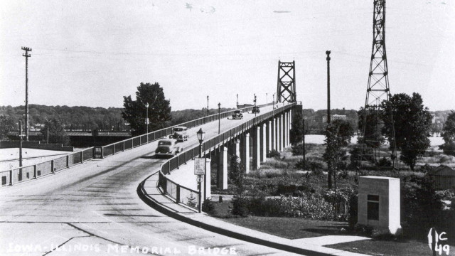
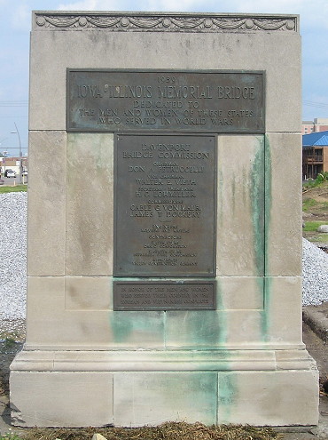
Facing south on 6 (date unknown)
Copyright © Iowa Department of Transportation. All rights reserved.
In the foreground you can see a small "Iowa US 6" shield with toll rates on the light pole, and a marker for the bridge's dedication.
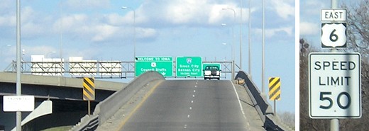
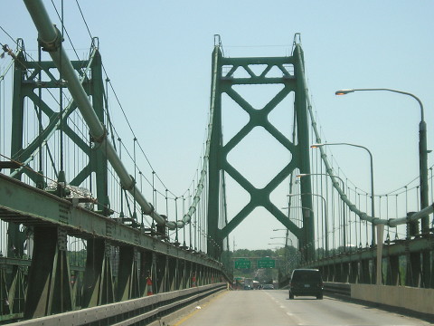
Facing south, but heading east, on 74/6 (5/22/12)
Things are going to start changing here in a big way... eventually. Little by little, steps are being made to replace the twin bridges across the Mississippi River, which might happen at the beginning of the next decade. US 6 runs with I-74 for about half the latter's length in Iowa, joining at Spruce Hills Drive instead of following old Kimberly Road just to the west. Kimberly Road runs into 13th/14th streets, which run parallel to the interstate near the river.
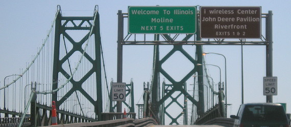
Facing south, but heading east, on 74/6 (5/22/12)
The kerning on these signs can't be helped, but that and the lowercase "i wireless" make me stabby.
Facing south, but heading east, on 74/6 (5/22/12)
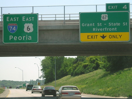
Facing north, but heading west, on 74/6 (4/18/06)
A photo could have been taken 70 years ago in this position, and not only that, but it would still have been on US 6. This span opened November 18, 1935, and the twin to the left (the southbound lanes) opened in 1959, though "the rest" of I-74 in Iowa wouldn't be built for another decade.The eastbound (southbound) bridge was built in 1959. As you can see, the bridge is narrow and not up to interstate standards.
Facing north, but heading west, on 74/6 (6/1/13)
Notice how the offramp flows directly into the street, and also that we're still on the bridge approach from the river.
The bridge approaches were rebuilt in 1974. The Iowa DOT compiled a detailed historic study of the bridge in 2012 (PDF).
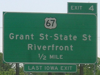
Facing north on the offramp/14th Street (6/8/15)
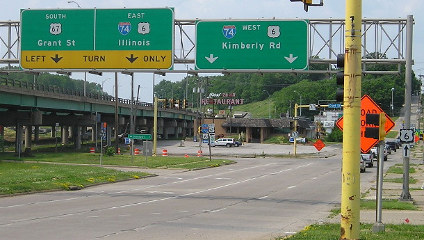
The southbound (eastbound) mainline of the new I-74 bridge will go right over this position. There will be no access to Kimberly Road from the exit. Kimberly Road will bend around and intersect Grant Street (US 67, changed to two-way for five blocks) on the west side of I-74.
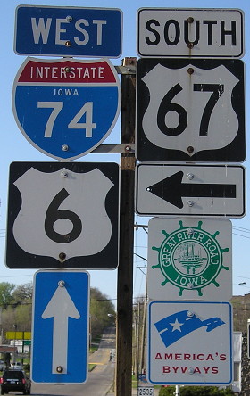
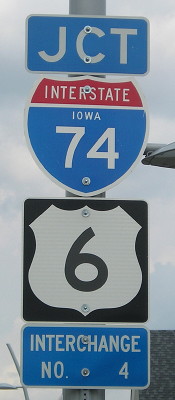
Facing north on the offramp/14th Street (4/18/06)
Iowa signage at its finest, including a somewhat-rare state-name I-74 shield.
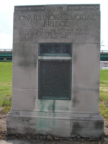
The 1935 marker for the original bridge was the last element standing in this area in summer 2015. It is going to be relocated and preserved.
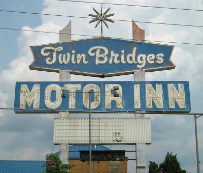
The Twin Bridges Motor Inn is the first/last property remaining on Grant Street east of the construction area for the new bridge. But soon it won't be, because the 55-year-old motel has fallen into disrepair and will be demolished. (6/8/15)
Facing east, but heading north, on US 67 (6/8/15)
Page created 7/3/06; last updated 6/3/20