Waterloo-Cedar Falls Highway Chronology
In the auto trail era (1910-26), Black Hawk County was on two major routes: The Red Ball Route, running from St. Louis to St. Paul, a forerunner of the Avenue of the Saints; and the Hawkeye Highway, which ran from Dubuque to Sioux City via Waterloo, Fort Dodge, Cherokee, Le Mars, and Sioux City. (It angled northwest, along today's IA 7 corridor, because the route hewed close to the Illinois Central Railroad.) There was a minor trail, the La Crosse-Tama-Kansas City Route, running more directly north and south.
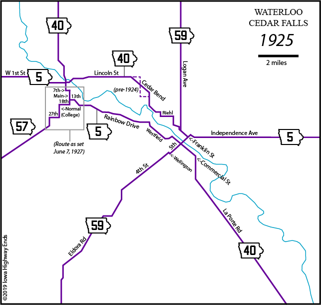
There were three main routes between Waterloo (1910 pop. 26,693) and Cedar Falls (1910 pop. 5012): North of the Cedar River along the Illinois Central, south of the Cedar River near the interurban, and even farther south. Huebinger's 1912 Map and Guide for Hawkeye Highway put the Hawkeye on this southernmost street, a 7-mile rural road named Cedar Falls Avenue. However, later that decade (possibly April 26, 1918, given a date on an old map), more attention was directed to the middle route, Whitney Road. This road was renamed Rainbow Drive on Dec. 2, 1919, to honor the Rainbow Division of World War I.
Rainbow Drive, the first hard-surfaced rural road in Black Hawk County, opened June 10, 1920. The Waterloo Evening Courier reported, "The pavement is of concrete base with a bituminous, filled brick surface - the best that money can buy. The road is 18 feet in width[.]" The road also passed by the two most important facilities of the time. First, there was the newly opened Hippodrome at the National Cattle Congress (today's McElroy Auditorium [update: they're back to calling it the Hippodrome]). Second, the route passed the factory that started as the Waterloo Gasoline Engine Company but, in March 1918, had been purchased by a plow manufacturing company from Moline interested in getting into the newfangled tractor business.
Six weeks after Rainbow Drive opened, Black Hawk County let a contract to paint signs for the new Iowa highway system. The Hawkeye Highway, also known as the Grant Highway since 1916, became IA 5; the Red Ball Route, IA 40; the L.T.K., IA 59; and a road from Cedar Falls past Iowa State Teachers College to Grundy Center, IA 57.
The area covered in this map is approximately that of the current Waterloo-Cedar Falls inset on the state map, plus southward to Hudson. Running from upper left to lower right is the Cedar River. Each year's box lists the street routing for major highways and the junction or end points for certain routes. Underneath that, all the changes that happened between that map and the next. All "Courier" references are to the daily newspaper in Waterloo that has gone by an assortment of names over the years. (Not all articles are listed.) Dates also come from Iowa Highway Commission meetings and Jason Hancock's research.
Known tweaks in the area in 1924 were on the south side of Hudson (IA 59 moved from Hudson Road and Wood Street to the Washington Street diagonal south of the school), northwest of Waterloo (IA 40 moved from Donald Street, Wagner Road, and a portion of present-day Airline Highway to an extension of Cedar Bend Street paralleling the railroad on the south), and southeast of Washburn (IA 40 flipped to stay on the west side of the railroad instead of crossing twice between Washburn and present-day Eagle Road/D46).
|
IA 5, W-E: 1st Street, Franklin Street, 7th Street,
Main Street, 13th Street, Waterloo Road, Rainbow Drive,
Whitney Street, Westfield Avenue, McKinley Street, Miles
Street, Commercial Street, 5th Street, Independence Avenue The Courier got wind in early February 1926 of the new highway numbers coming and printed the Highway Commission's 1925 maps then and in October showing what the new system would look like. But on October 16, 1926, US 20 was signed on the north side of the Cedar River and US 218 on the south side. It meant US 20 replaced IA 5 and US 218 replaced IA 40 except between Cedar Falls and IA 59. Instead, 20 took 40's route and 218 took 5's route. The Highway Commission refused to change this at its meeting December 14, because this version kept traffic for 20 and 218 off the Fifth Street Bridge. City leaders were, to use a phrase not in use at the time, cheesed off. ("City officials indignant over new road route," Courier, Dec. 17) Incidentally, just off the intersection of East Fifth and Franklin (where the Red Ball and Hawkeye used to meet, but now 20 and 218 would not) was a prominent Willys-Overland car dealership building, which 30 years later would become the base for eastern Iowa's NBC-TV station, KWWL.1929: 20 moved from 5th Street to 6th Street between Franklin
and Independence |
|
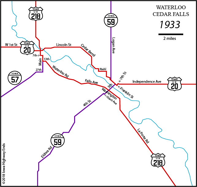
US 20, W-E: W 1st Street, Lincoln Street, Cedar Bend
Street, Parker Street, Burton Avenue, Riehl Street, Broadway
Street, Park Road, Oak Avenue, Franklin Street, 7th Street,
Walnut Street, Independence Avenue Jct. 20/59: Franklin/Logan to Franklin/5th October 13, 1933: Reroute of 20 along Parker Street and Logan
Avenue approved upon completion of paving of Parker Street — but
the change never happened. The reason is unknown. |
|
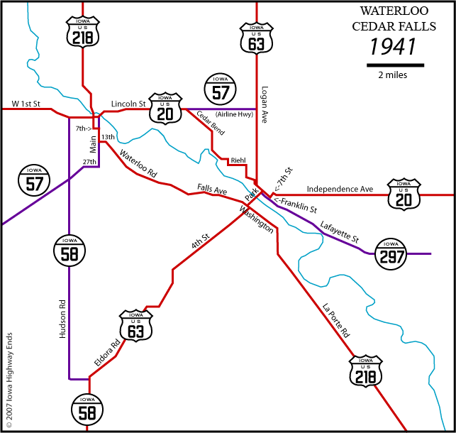
US 20, W-E: W 1st Street, Lincoln Street, Cedar Bend
Street, Parker Street, Burton Avenue, Riehl Street, Broadway
Street, Park Road, Oak Avenue, Franklin Street, 7th Street,
Walnut Street, Independence Avenue Jct. 20/63: Franklin/Logan to Franklin/5th 1940s: 218 connector between Main and Franklin in Cedar Falls
changes from 7th Street to 4th Special mention: The 1961 resurfacing of the soon-to-be-previous alignment of US 63 between Hudson and Waterloo used maps from the 1924 paving of IA 59. Much later, a 2018 document for work on IA 21 in Tama County called back the initial plans for IA 402 four decades earlier. That is some fine record-keeping. |
|
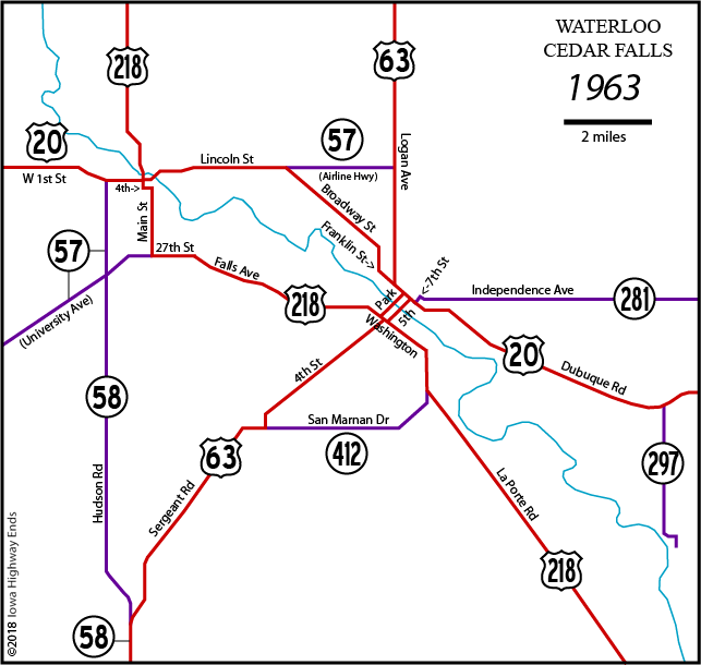
US 20, W-E: W 1st Street, Lincoln Street, Broadway
Street, Franklin Street, Dubuque Road US 63 across the Cedar River: 2/15/35 to 4/2/40, Fifth Street; 4/2/40 to 11/22/50, Park Avenue; 11/22/50 to 12/16/68, NB Park Avenue, SB Fifth Street; 12/16/68 to 10/9/69, NB Park Avenue, SB Mullan Avenue; 10/9/69 to 2/16/70, NB First Street, SB Mullan Avenue; 2/16/70 to 11/23/70, NB First Street, SB Fifth Street; 11/23/70 to present, NB First Street, SB Mullan Avenue Jct. 20/63: Franklin/Logan to Franklin/5th May 29, 1963: West end of 281 set Seventh at Franklin |
|
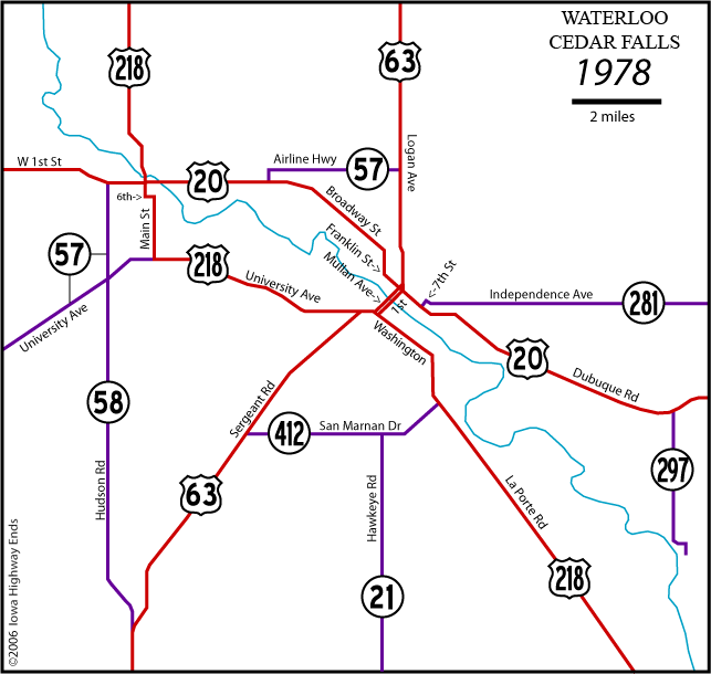
US 20, W-E: W 1st Street, Broadway, Franklin Street,
Dubuque Road Jct. 20/63: Franklin/Mullan (NB) and Franklin/1st (SB) 1978-81: I-380 drawn in as dashed line through Waterloo all
the way up to George Wyth State Park; built as US 218 decade
later |
|
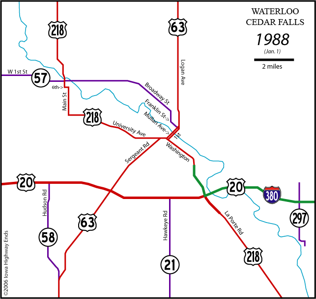
US 20, W-E: Freeway, with I-380 east of 218;
interchanges at IA 58, Butterfield Rd, US 63, IA 21, I-380/US
218 Jct. 20/63: Interchange November 15, 1988: 281 brought back to east city limits of
Waterloo |
|
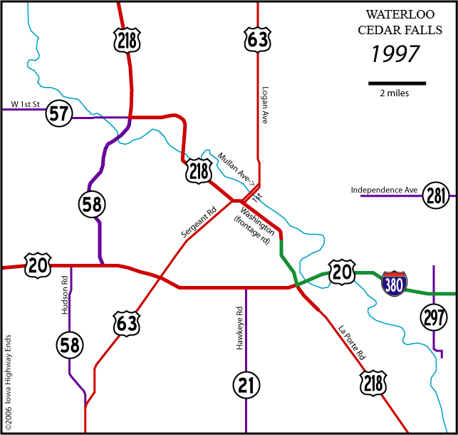
US 20, W-E: Freeway, with I-380 east of 218;
interchanges at IA 58 S, IA 58 N, US 63, IA 21, I-380/US 218 Jct. 20/63: Interchange March 11, 1998: DOT takes much of University Avenue back with
little fanfare, creating secret IA 934 |
|
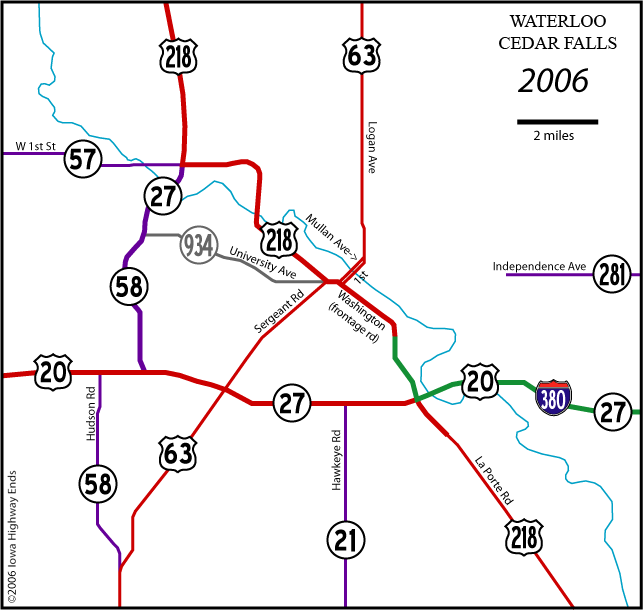
November 9, 2006: Ansborough Avenue exit opens on US 20 |
What if?
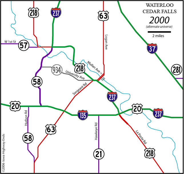
This map shows what might have happened if the Avenue of the Saints had been included in the original interstate system and followed US 63 north of Waterloo instead of US 218, and also if a four-lane US 20 had been part of, say, the 1968 addition to the Interstate Highway System. I believe that many of the four-lane roads built in the 1980s and 1990s would still exist, in the Waterloo area, but in slightly modified forms.
Page created 2/18/05; last updated 10/13/21