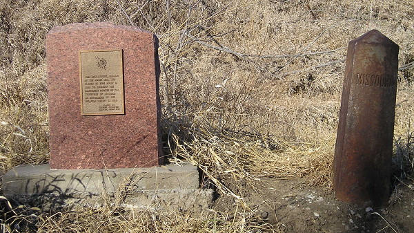
Sullivan Line marker near Athelstan, Taylor County IA/Worth County MO. Photo taken 1/10/12. See also this blog post.
Every Civil War and/or American history scholar knows exactly where the southern border of Missouri is. West of the 'bootheel', the line is 36 degrees, 30 minutes north latitude - the line of the Missouri Compromise. For Missouri to be added as a (slave) state in 1820, (free) Maine would follow, and slavery would be banned west and north of the line. The Missouri Compromise was nullified with the Kansas-Nebraska Act and declared unconstitutional in the Dred Scott case, and the rest is bloody history. But what about the northern line - that is, the border with Iowa? Its position and existence seem to be taken for granted. But it shouldn't, thanks to an erroneous surveyor and three bee trees.
The problem with the northern line is that it was not set by latitudinal statute. In the Enabling Act of the State of Missouri in 1820, the west border of the state (going north from 36°30') was to be due north and south of the mouth of the Kansas River, "to the intersection of the parallel of latitude which passes through the rapids of the river Des Moines, making the said line to correspond with the Indian boundary line; thence east from the point of intersection last aforesaid, along the said parallel of latitude, to the middle of the channel of the main fork of the said river Des Moines; thence down and along the middle of the main channel of the said river Des Moines" to the Mississippi and then south. The northwestern corner of the state, including the city of St. Joseph, was not added until the Platte Purchase in 1837. This northwest corner of Missouri is a few miles west of Athelstan, Iowa (Taylor County).
The "Indian boundary line" in question was drawn by J.C. Sullivan in 1816. He was told to delineate the space between the Osage Indians and the then-Missouri Territory. From various websites, the consensus appears that he worked in an easterly direction, which leads to the problem. Sullivan either forgot about, ignored or was unaware of magnetic declination - that is, the difference between what your compass says is north (the magnetic north pole) and what is really north (90 degrees north latitude, the geographic north pole). From where he started in western Missouri, the (21st-century) declination is approximately 4 1/2 degrees; at the Des Moines, the declination is 2 degrees. Thus, as Sullivan worked east, the "straight" line angled to a decidedly east-north-easterly direction, especially in the eastern third, and he reached the Mississippi in what is now downtown Fort Madison, approximately three miles north of where he should have been. Whoops. The problem was compounded when the southern boundary of the Wisconsin Territory was stated to be the northern border of Missouri, locking the two in an endless loop.
The "rapids of the river Des Moines" was a point of contention in the late 1830s, when Sullivan's marks had disappeared and the Iowa Territory was being carved out. Missouri commissioned a Mr. Brown to re-survey the land. However, there was an error in communication: Sullivan's "rapids of the river Des Moines" were actually in the Mississippi, the name given by the locals, as the features in question were a few miles north of the Des Moines River. Brown instead went looking for the Des Moines Rapids on the Des Moines River, and believing to have found them near the big bend in the river near what is now Keosauqua, went and did his surveying from there. Brown's line is, or is approximately, halfway up the last tier of counties, two townships' worth. The north side of Mount Ayr would straddle and Centerville would be bisected by this line (if that was the one).
The border having been so drawn, Missourians decided it was time "their" land contributed to the tax base. When the people, most of whom considered themselves Iowans, answered this demand with raised pitchforks, trees that bees used to store honey (inevitably referred to as "bee trees") were cut down and the honey used as payment. The arrest of a Missouri sheriff followed, and in December 1839 hundreds of Iowans and Missourians headed to the Van Buren-Clark County area to defend their states. (This was the first use of the Iowa National Guard.) Fortunately, cooler heads prevailed, and the Supreme Court was called in to decide the matter. Eventually, in Missouri v. Iowa, 7 How. 660 (1849) and Missouri v. Iowa, 10 How. 1 (1851), a line was physically marked, and that marking was reaffirmed in Missouri v. Iowa, 160 U.S. 688 (1896). (Numbers are Supreme Court case files.)
Despite the incident that led to the Honey War happening in Van Buren County, that county got the worst lot in the end. Although the case was ruled in favor of Iowa, following Sullivan's Line, by that point the eastern half of the county had already lost two north-south miles. Had the line been drawn horizontally, present-day IA 81's length would have doubled, and Croton in Lee County would be where the straight boundary ended. Croton - or Athens, Missouri, just across the river - is the site of the northernmost battle of the Civil War, according to Croton's website (now defunct) and the Missouri Department of Natural Resources. Since there is a house that shows holes made by a cannonball, one is inclined to believe the claim.
The land east of the Des Moines River was never really in dispute. Sullivan's Line formed the north edge of a triangle called the Half-Breed Tract, set aside for those of mixed race in 1824. Ten years later, speculators swooped in on the land, and it took another nine years for everything to be sorted out. Today, the line is still used to divide Lee County land administration between the two county seats at Fort Madison and Keokuk.
What if instead of following treaty lines, Sullivan was told to follow a specific degree of latitude? The best one for the job, at least retroactively, seems to be 40 degrees, 35 minutes north. The DeLorme Iowa Atlas and Gazetteer marks 40°35'15", but not the whole minute. The USGS says that a second of latitude is approximately 101 feet, and a minute 6068 feet; thus, 40°35' is about 1515 feet south of that line, or about .28 miles. Making a map was helped immensely by that line and the fact that County Road J62 is just a tiny bit north of it (not shown; see state maps).
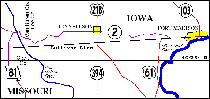
This map is drawn with 2002 highway routes because, plain and simple, it's a lot easier to draw that way. (There is something to be said for straight, non-bypassing roads.) It shows the Sullivan Line and 40°35' running across Lee County; west of the Des Moines, the Sullivan Line is the state line. From west to east ends on this map, the line moves northward approximately one mile; on the west side of Fort Madison, US 61 and IA 2 actually use it for a bit before turning north and meeting what was IA 103 (see page). Using DeLorme's Street Atlas computer program and the USGS conversion numbers for latitude, here is a list of points on the Sullivan Line and their variance from 40°35', east to west, in decimal minutes to the nearest hundredth of a minute (which is ~60 feet, 8 inches). From this we can see that the border is definitely not truly straight, although it may look or be drawn that way on maps:
| PLACE | LATITUDE | DIST (FEET) FROM 40°35' |
| Fort Madison shoreline | 37.65 | 16080 (just over 3 miles) |
| US 61/IA 2, west intersection of road and Sullivan Line | 37.58 | 15655 |
| US 218, 1/2 mile north of former IA 394 junction | 37.12 | 12864 |
| Des Moines River, 2 miles south of Farmington, where state line follows river; northernmost point in Missouri | 36.83 | 11104 (2.1 miles) |
| MO 15, southwest Van Buren County | 36.07 | 6492 (just under 1 1/4 miles) |
| US 63, Davis County | 35.62 | 3762 |
| IA 202 at Coatsville, Missouri, near south Davis/Appanoose corner; Coatsville is farther north than Athelstan, Iowa | 35.46 | 2791 (just over 1/2 mile) |
| IA 5, 5 miles southwest of Cincinnati | 35.21 | 1274 (just under 1/4 mile) |
| State line crosses 40°35' at County Road S60, 1 mile west of Appanoose/Wayne line | ||
| US 65 at Lineville; Sixth Street, 1/5 mile north, follows latitude line | 34.82 | -1092 |
| Interstate 35/US 69 | 34.52 | -2913 (-0.55 mile) |
| US 169, 2.5 miles south of Redding | 34.28 | -4370 |
| Athelstan, southeast Taylor County, at or near southernmost point of Sullivan's Line; also near where the line began | 34.25 | -4551 (-0.86 mile) |
| IA 148, 1.5 miles northeast of Hopkins, Missouri | 34.40 | -3641 |
| US 71 at Braddyville | 34.58 | -2549 (just under 1/2 mile) |
| US 59, 1.3 miles south of County Road J64/former IA 333 | 34.85 | -910 |
| State line crosses 40°35' halfway between County Road L68 and US 275 in Fremont County | ||
| Interstate 29 | 35.06 | 364 |
| Western state corner | 35.11 | 667 |
| Difference between Iowa's southernmost point on line (Athelstan) and Missouri's northernmost point (Des Moines River) | 2.58 degrees (36.83-34.25) | 15655 (nearly 3 miles, less than a football field short of that) |
| Difference between Coatsville and Athelstan (western 7/9, or 78%, of line) | 1.21 degrees (35.46-34.25) | 7342 (~1.4 miles) - note that eastern 22% adds 1.6 miles |
If the line of 40°35' were to be made the boundary by joint legislative acts (and Congress?), I don't know which state would win land-wise, though I'm guessing it's Iowa. Iowa would also gain the unincorporated communities of Coatsville and Athens (including much but not all of the Battle of Athens State Historic Site). On the other hand, Missouri would gain all or most of incorporated Blanchard, Braddyville, Athelstan (since disincorporated), Pleasanton, and half of Lineville, plus the entirety of the I-35/US 69 interchange. Maybe Iowa got the better end of the deal after all. Perhaps Iowa's battle cry should be "40°34' Or Fight".
Sources/Further reading:
Page and graphic created 1/13/05; last updated 2/8/16