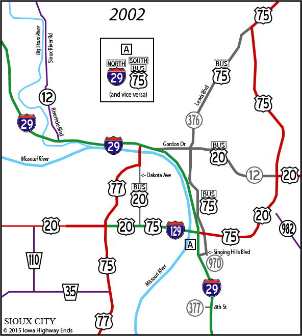
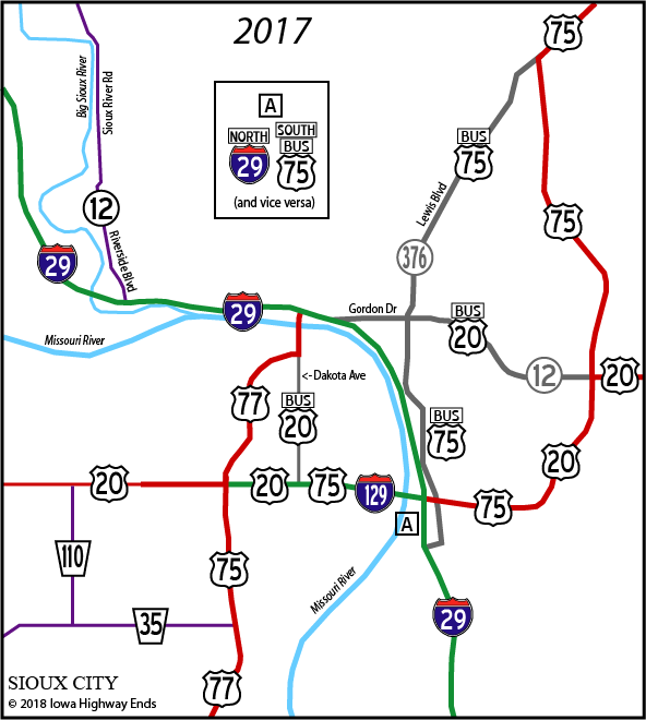
Sioux City Highway Chronology
The area covered in this map is approximately that of the Sioux City inset on the state map. The Woodbury/Plymouth county line is just below the north edge of the box. Each box lists all the changes that happened between the above and below maps. Four-lane roads are shown as thicker lines, although in this case they are more like urban arterials than freeways/expressways. Gordon Drive, Lewis Boulevard, and the four-lane roads in Nebraska other than I-129 have at-grade intersections.
The Combination Bridge connecting foot, wagon, and rail traffic between Sioux City and South Sioux City opened January 21, 1896 — the fifth-oldest border bridge to be incorporated into the Iowa highway system.
|
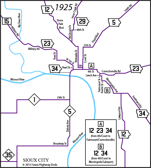
IA 12/23/34 triplex route: 4th St,
Plymouth St, Westcott St, 2nd St/Fairmount St (EB) and 1st St (WB),
then south to
intersection of Fairmount/Correctionville End IA 5: Probably Court at 4th.
IA 29 may or may not have been duplexed a block with it. No
connection to NE 5. A 1919 Sioux City map from the University of Texas' Perry-Castañeda Map Collection shows Pierce Street, two blocks east of Pearl Street, as both the north-south segment near the Combination Bridge and for IA 12/29 heading north. (Pierce runs into Stone Park Boulevard at 27th Street.) The above is reflective of the 1925 state map, the first with city insets. In 2018, the block of Pearl between 3rd and 4th was vacated completely to make more parking spaces for the Hard Rock casino. October 16, 1926: US 20 replaces IA 23 east of downtown,
IA 34 in downtown, and NE 1; US 75 replaces IA 5 and IA 12 south of
downtown; US 77 replaces NE 5 in South Sioux City; IA 141 replaces 23
west of downtown. (The original routes seem counterintuitive, which is
why
an earlier edition of this map had to be corrected after looking at the
DOT's archives.) |
|
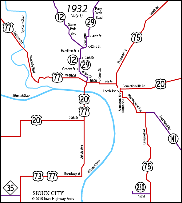
Jct. 20/75: 4th/Plymouth to
Correctionville/Fairmount |
|
US 20 downtown: Toll bridge, 3rd St, Pearl St, Riverside Dr, Grand Ave (which becomes Correctionville Road) Jct. 20/75: Correctionville/Westcott
(slightly east of present interchange; Westcott goes north to become
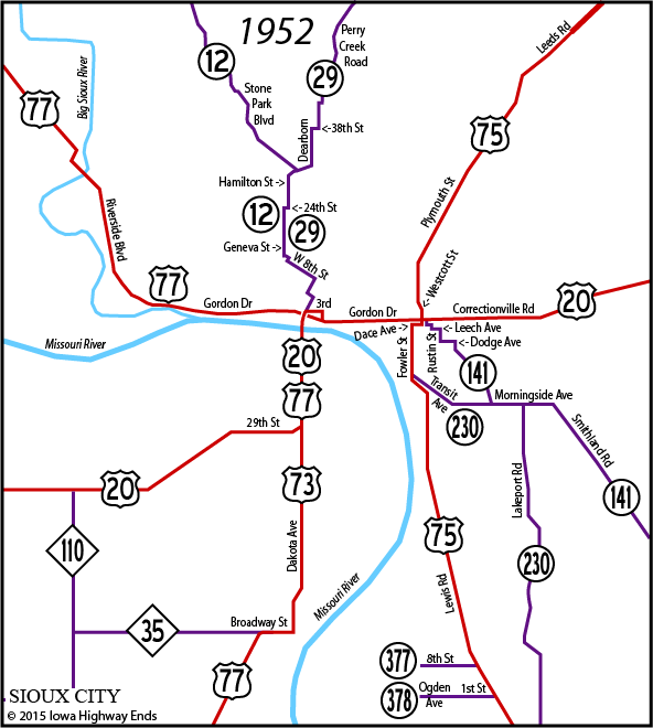
Plymouth) NOTE: A 1939 construction plan shows work on Transit Avenue between US 75 and Rustin Street, but I can't find any other evidence that Transit between 75 and Morningside was a state highway prior to 1948. NOTE: Exact date of realignment of US 77 off much of Military Road in North Sioux City (to the other side of railroad tracks with double underpass) unknown. Aerial photos indicate road existed as early as late 1930s. 1940s: IA 141 moved from Jay Avenue and Rustin Street to
Cecilia Avenue and Dodge Avenue between the Morningside/Cecilia and
Dodge/Rustin intersections |
|
Jct. 20/75: Gordon/Westcott. US 20
transitions to/from Correctionville Road via now-vanished short
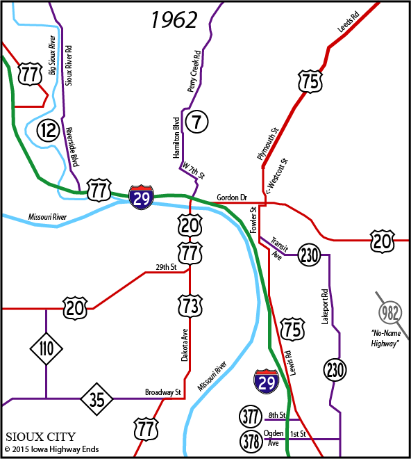
diagonal east of Linn Street. NOTE: It is possible that IA 141 was routed onto Transit and Fowler instead of Palmetto and Gordon from sometime in 1955 to sometime in 1956. It is possible that IA 230 was duplexed with Fowler up to US 20 in 1955 or 1956 until 1957. Or they both could be inset map errors. NOTE: Sioux City inset maps from 1952-55 show the northernmost part of IA 12 on Memorial Drive and Talbot Street (west of Stone Park Boulevard) but there has never been a road running north from Talbot to present-day K18. The main map was not affected. I believe this to be a map error until proven otherwise.1954: IA 12/29 moves from 8th Street to 7th Street near downtown November 24, 1954: US 20 shifted onto new Gordon Drive alignment east of Combination Bridge ("New Highway 20 Is Now Open," Kingsley News-Times, Nov. 25); IA 141 moved onto it 1955: IA 29 reconstructed from Perry Creek northward to city limits, eliminating very early 16-foot-wide concrete paving, clipping some old curves, and eliminating Summit Street/38th Street portion 1956: IA 141 returned to old route between Morningside Avenue and US 20, except using all Fairmount instead of Fairmount-Dace-Linn between Leech Avenue and 20 1957: IA 378 extended east to IA 230 1957: Iowa swing span (northernmost part) of Combination Bridge removed; US 77 bridge over future I-29 built in same position June 25, 1957: US 75 opens to four lanes undivided from 14th Street to 41st Street and then four lanes divided, with interchange at 46th Street/Floyd Boulevard, up to Plymouth County line ("Highway 75 To Open Tomorrow," Le Mars Globe-Post, June 24) October 10, 1957: IA 12 put on newly paved Sioux River Road, which runs into Riverside Boulevard, along the Big Sioux River, ending duplexed with US 77 at junction with 20 November 1957: IA 29 renumbered IA 7 ("Highway 29 Is No More; Is Highway 7," Le Mars Globe-Post, Dec. 9) December 15, 1957: Combination Bridge interchange and four-lane road opens from the intersection of Pearl Street and Gordon Drive west to Isabella Street (now Hamilton Boulevard). This was the first contracted segment of the interstate system in Iowa. February 5, 1958: IA 12 extended from Riverside Boulevard to the Combination Bridge interchange 1958: IA 7/new Hamilton Boulevard straightened between 7th Street and Dearborn Boulevard October 1, 1958: Stretch of I-29 between Riverside Boulevard and future Gordon Drive exit (including earlier-built piece) opens; IA 12 truncated back to Riverside interchange March 11, 1959: First entry for I-29 in primary route descriptions, but it was likely signed earlier November 28, 1959: I-29 opens south of present-day Singing Hills Boulevard, then named Industrial Road July 15, 1960: I-29 opens from US 77 to Singing Hills; US 20 (Gordon Drive) reworked/expanded between Pearl Street and Floyd Boulevard 1960: Westcott Street (US 75) bridge over old Floyd River channel rebuilt (this bridge still exists today, but over dry land, visible in the southeast quadrant of the intersection of Lewis Boulevard and 3rd Street) June 1, 1961: IA 141 removed from Sioux City area to meet I-29 at Sloan ("New Section of Paving Opened Near Smithland," Mapleton News, June 1); IA 982 was designated for old route a week earlier December 15, 1961: New I-29 bridge into North Sioux City SD opens; 77 put on 29 across river ("Dedicate Interstate Linking Iowa, South Dakota," Sioux City Journal, Dec. 15) |
|
Jct. 20/75: Gordon/Westcott |
|
Jct. 20/75: Interchange, Gordon
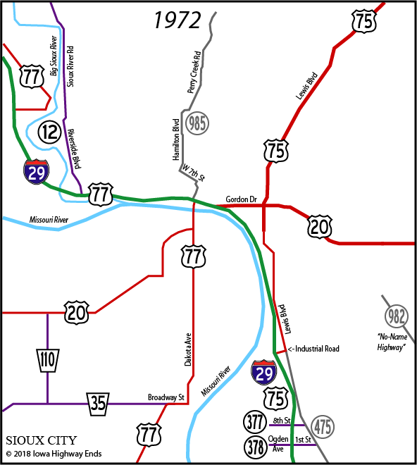
Drive/Lewis Boulevard 1972: I-29 Isabella Street exit renamed Hamilton
Boulevard after
extension of city street |
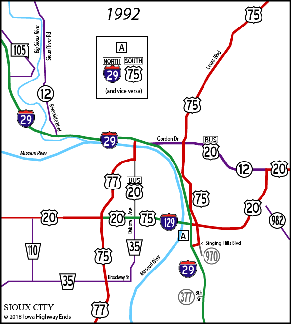
| December 23, 1994: Sioux City takes
nearly all its remaining part of IA 970 December 27, 1996: IA 970 decommissioned in Woodbury County (K42 to Sergeant Bluff excluding the already-dropped segment through Salix) 1998: SD 105 allegedly decommissioned in North Sioux City. Official county map shows 105 is only near Elk Point (off this map), but 2000 state map and I-29 exit sign in June 2005 still indicated 105 in area. 2000: IA 12 signage removed along I-29 and Business 20 2000?: NE 35 decommissioned in Dakota City to end at US 75/77 November 19, 2001: US 75 freeway opens on east side, removing multiplex with I-29 and adding multiplex with US 20; old 75 becomes Business 75 and secret IA 376 |
| Early 2000s: Business 20 signage at
east I-29 split removed; signs at US 77 interchange remain March 28, 2002: Sioux City Stockyards close, leaving some signs on I-29 blank for years July 1, 2003: IA 982, remainder of IA 970, and remainder of IA 377 decommissioned 2006 or 2007: US 20 four-laned from previous end west to Jackson NE 2010: Decade-long project to modernize and expand I-29 to six lanes throughout Sioux City begins 2012: IA 12 interchange converted from trumpet to diamond |
Some information used from "Sioux City's Grand Avenue Viaduct 1936-2010" on the Iowa DOT's website.
Page created 9/10/05; revised and expanded 1/25/15; last updated 1/14/18