Ottumwa highway chronology
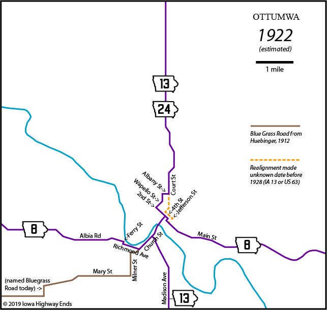
These maps show the highway evolution in the city of Ottumwa and the immediate area. US highways are in red, state highways in purple, business routes in green, and four-lane limited-access highways in thicker lines. The Des Moines River runs from middle left to bottom right; downtown Ottumwa is just north of the river along Main Street.
| Across
the river northeastbound: Eastbound 8, northbound 13,
named Church Street south of the bridge and Market Street north
of it. Bridge
built
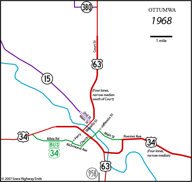
in 1892. The top two maps are based on two sources: Huebinger's Map and Guide for Blue Grass Road (1912) and a map in Iowa Highway Commission minutes microfilm. The cross-state Blue Grass Road running west out of Ottumwa passed through Blakesburg, Albia, Melrose, and Russell. In March 1917, the Highway Commission selected a more direct route between Chariton and near Melrose named the State Road, and in June of the same year did the same between Albia and Ottumwa. In the summer of 1919, the final decision was made to use the straighter route for the future primary. ("State Road Selected," Chariton Herald-Patriot, June 19, 1919) July 1, 1920: IA 8, 13, 24 designated At some point between 1912 and 1928, a slight change was made to the north-south road. Instead of using Albany Street, Wapello Street, and 2nd Street to come into downtown, it followed Court Street to 4th Street to Jefferson Street, passing by the Wapello County Courthouse. This changed the east-west road to use 4th/Jefferson instead of 2nd/Green between Market and Main. October 16, 1926: US 63 takes over IA 13 through Ottumwa, but then IA 24 to Oskaloosa; US 34 takes over IA 8 July 23, 1929: US 34/63 rerouted to use Vine Street across the river on a bridge that was built in 1898, and 34 to use Vine between Madison Avenue and Church Street |
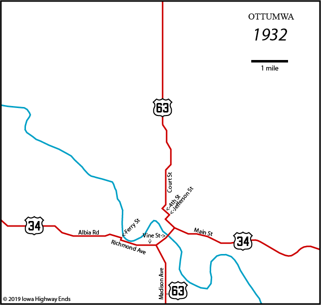
| Vine
Street northeastbound: Eastbound 34, northbound 63.
Vine, Richmond, and Church meet at a five-way intersection with
Willard Street that eight decades later would be home to a
McDonald's and closed Long John Silver's. June 6, 1933: US 63 rerouted onto Jefferson Street and Vanness Avenue north of downtown, taking route away from courthouse May 28, 1936: Jefferson Street viaduct opens; US 34 and 63 are rerouted away from Vine Street onto alignments that use the new viaduct approved in December 1934. June 22, 1937: IA 15 commissioned |
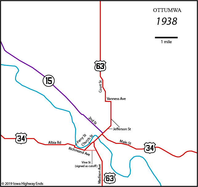
| Jefferson Street
northeastbound: Eastbound 34, northbound 63 1943: IA 380 created to serve Ottumwa Naval Air Station (later Ottumwa Industrial Airport). The end of the highway is at the airfield's entrance, just above the top border of this map. 1954: IA 15 converted to one-ways on Main/2nd between Jefferson and Wapello streets. At least part of this could have happened earlier but 1955 is the first state map to show highway lines on both. June 11, 1954: Two-mile segment of new 34 opens, from a point just west of the future Business 34 intersection halfway to Agency. This segment is the fourth piece of rural four-lane highway to open in Iowa, although it has a narrow median. September 1955: Realigned two-lane 2.5-mile segment opens between the east end of the four-lane and Agency. September 24, 1957, was a big day in the Ottumwa Courier. First, there was the big national news - "Ike Calls Out Troops For Little Rock" (federalizing the National Guard to integrate a school). Then, right underneath, a photo of the new US 63, which opened from 4th to Court that day. (Trucks would soon be told to use the old route to avoid two turns and clogging up Main Street.) Finally, at the bottom of the page, "Interstate Highway Marking Plans Are Told." The official numbers of 29, 35, and 80 were announced as roads for Iowa, with the note that more numbers would be needed in Council Bluffs, Des Moines, and the Quad Cities. While pre-bypass 63 remained on Court Street north of the new segment (the curvy part), between that intersection and downtown the highway is four lanes with no street designation and a narrow median, which did have grass until the mid-2000s. November 1958: The 1955 segment to Agency gets two more lanes. The map below shows the end of the year. |
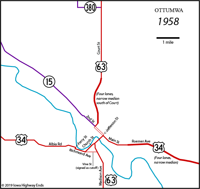
|
NOTE: US 63 uses pair of one-ways on Main/2nd. Jefferson Street northeastbound: Eastbound 34, northbound 63 The 1960s were decidedly Ottumwa's decade for highway construction. Included in this was a project to straighten the Des Moines River's course and create an oxbow lake; the Wapello Street viaduct crosses this new part of the river. October 15, 1962: US 34 realigned on far west edge of Ottumwa as part of project west to Albia1963: 63 four-laned from north end of new segment northward to golf course on north side of city July 9, 1964: US 34 realigned west of future interchange at Church/Jefferson streets September 4, 1964: Wapello Street viaduct opens; US 63 rerouted onto it and duplexed with 34 on the four-lane in the reverse direction (now west/north and east/south). Jefferson Street now only carries 34 across the river. Also in 1964: IA 15 broken up into one-ways on 2nd and Main west of Wapello Street; traffic to/from 63 connects via a ramp system since the intersection is at the north end of the viaduct. September 2, 1966: US 63 moved from Madison Avenue south of Church Street to a new road just east of Madison, including completed Church/Jefferson interchange and interchange at Vine Street. Myrtle Street now serves as eastbound frontage road connecting ramps at Church and Jefferson; Cook Street serves as the westbound counterpart. However, the speed limit on this road is only 45 MPH. December 12, 1967: New 34 east opens between new "mixermaster" intersection with 63 and Roemer Avenue, lengthening duplex and taking 34 off Jefferson and Main; Business 34 created. The alignments of 34 and 63 in Ottumwa will not change again for 39 years. |
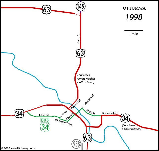
| NOTE:
Southeastward travel on the duplex is eastbound 34, southbound
63 January 1, 1969: IA 15 changed to IA 23 September 3, 1969: IA 380 renumbered to IA 389 1978 (according to paving records): 63 four-lane extended northward a little more than 1 mile from the previous north end to just north of IA 389 July 16, 1997: US 63 realigned between Oskaloosa and Ottumwa, including a new four-lane segment from near Chillicothe to old 63 north of Ottumwa; IA 149 extended southward; IA 23 and 389 decommissioned |
| NOTE:
Southeastward travel on the duplex is eastbound 34, southbound
63 July 1, 2003: IA 958 decommissioned October 2006: New two-lane US 34 opens on new alignment from Roemer Avenue eastward to Agency; 1954 four-lane reworked into two-lane frontage road. November 8, 2006: New "roundabout" at south 34/63 junction fully open to traffic. November 29, 2006: Other two lanes open on new segment of 34, completing new four-lane alignment from Ottumwa to Fairfield with bypasses of Agency and Batavia 2007: Business 34's western segment moved to Quincy Avenue, shortening distance on Albia Road; signage does not change all at once November 19, 2007: US 63 bypass opens; IA 149 extended; Business 63 created. New 34/63 duplex reverses the direction-reverse that happened in 1964 (changing to west/south and east/north). |
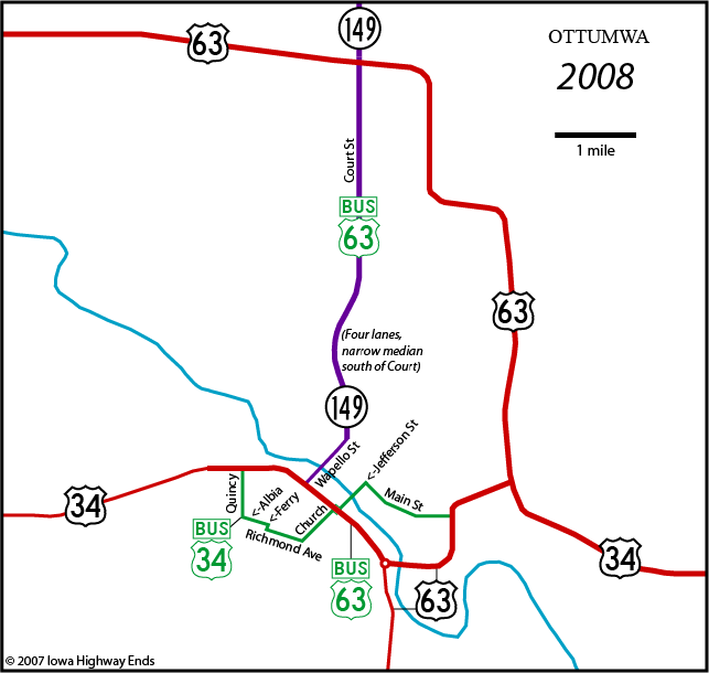
|
NOTE: Duplex from roundabout to new interchange is eastbound 34, northbound 63 End 149: Wapello Street at US 34 October 2009: IA 163 extended southeast from Oskaloosa to Burlington along US 63 and US 34 |
Page created 10/28/07; last updated 5/16/19