Fort Dodge Highway Chronology
These maps show the highway evolution in the city of Fort Dodge and the area to the south. US highways are in red, state highways in purple, business routes in green, and four-lane limited-access highways in thicker lines. The Des Moines River runs from top to bottom. Maps are based on DOT maps, Highway Commission minutes, and the article "Retro road trips still available for today's driver" from the May 3, 2009, Fort Dodge Messenger.
| NOTE: Central
Avenue
is broken at 4th Street to go around the park, goes past the
courthouse on 7th, and ends at the Chicago & Great Western
Depot on 12th. It's a major street to be sure, but that may be
exactly why subsequent routings avoid it. (To tell the truth,
that broken part of Central, which is the current site of the
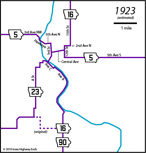
Fort Dodge Library, seems tailor-made for a courthouse.) IA 23, working north: A Street, Avenue G, C Street, Avenue D, D Street, Avenue C, Bennett Viaduct, 3rd Street. On the west side of the river, the avenues are east-west-ish and the streets north-south-ish, all lettered, while on the east side, that's still the case but everything is numbered. The Messenger article mirrors the map in Huebinger's Map and Guide for Des Moines, Fort Dodge, Spirit Lake, & Sioux Falls Highway (1912), except for the segment of IA 16 hugging the river, which was added in 1922. Otherwise, the match indicates stability in the 1910s and 1920s. According to the Messenger article, IA 16 transitioned from Avenue B to Avenue C at L Street. However, late 1930s aerial photos indicate that K Street may have been more likely. November 3, 1924: IA 90 truncated to Harcourt October 16, 1926: US 20 replaces IA 23 and IA 5 east of Fort Dodge |
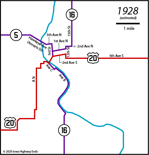
| 1930: New diagonal created for US 20 from
southwest of Fort Dodge (present Business 20/Business 169
intersection) to Moorland October 23, 1930: US 169 replaces IA 16 |
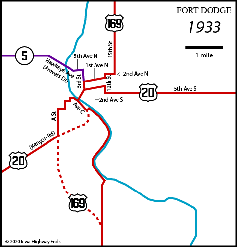
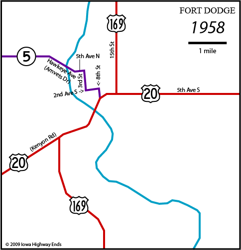
| NOTE:
IA 5 bridge uses road currently known as Amvets Drive, but at
the time was Hawkeye Avenue (the present-day Hawkeye crossing
the river was built later). This appears to remain true through
1960. End 5: 3rd Street at 2nd Avenue South, where it meets 20 Spring 1933: US 169 moved off Avenue B and River Road to road away from river. Possibly at the same time, Kenyon Road is completed to near the river, with 20 and 169 rerouted onto it and a curve to Avenue C (where the hospital is now) to use the old viaduct for a few more years. August 4, 1937: US 20/169 realigned onto Herring Viaduct (Kenyon Road extension); US 169 and IA 5 placed on 8th Street The Messenger and the Highway Commission disagree on downtown routings in the mid-1930s. The Messenger says that by then, 169 already followed a hybrid of later alignments east of the river, using North 12th Street and 2nd Avenue North to North 15th Street. However, a Highway Commission map from August 4, 1937, shows that before that date, 169 used the route shown above. The Messenger further says that 169 was routed "onto the Kenyon Road bridge in 1935, again sharing Highway 20's route along Fifth Avenue South to 15th Street." But multiple Highway Commission documents combine to say a) the bridge plans weren't finished until April 1934, b) the highways were not routed onto the bridge in question until 1937, and c) 169 split from 20 at the north end of that bridge (the modern 926/Business 20 intersection), following 8th Street and winding northeast to 15th, as shown below. |
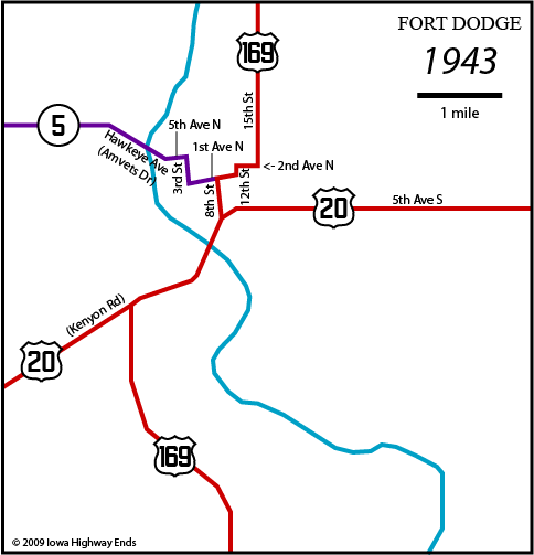
| End 5:
8th Street at Kenyon Road near northeast end of the
viaduct, where it meets 20 Assuming the Highway Commission map is correct, 169 is straightened sometime in the 1940s (instead of the '30s) to use 15th Street down to 20 while 5 moves back onto 2nd Avenue South. |
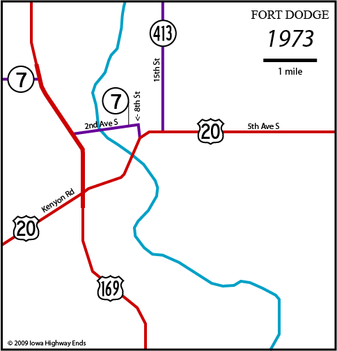
| November
8, 1960: New four-lane US 169 opens on west edge of town, with a
unique trumpet interchange at the south IA 5 junction - County
Road D22 intersects the ramps. Old 169 north of 15th Street
becomes IA 413. December 7, 1960: Karl King viaduct opens on 2nd Avenue South, completing link to new 169 and rerouting IA 5 away from its previous northwest entrance. Segment that, at the time, was outside Fort Dodge city limits on 3rd Avenue NW designated IA 997 for one year. January 1, 1969: IA 5 changed to IA 7 |
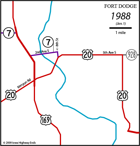
| 1980:
IA 413 decommissioned (except if you're KCCI, where a map in
2009 still had it). July 2, 1987: New four-lane 20 opens east of Coalville; old 20 temporarily designated IA 928 for approximately a year until Webster County assumes jurisdiction. Hamilton County doesn't, however, and 928 remains the number for old 20 over there (except in Webster City) for the next 15 years. |
| November 19, 1990: New four-lane 169 opens to
meet new 20, bypassing part of old road December 7, 1990: New four-lane 20 opens south of Fort Dodge, with two-lane extension west of 169; old route redesignated Business 20; IA 7 truncated to northwest corner of town with 2nd Avenue segment signed solely as Business 169 and given secret designation of IA 926. 1991: Old 20 turned over to Fort Dodge (5th Avenue) and Webster County (diagonal segment temporarily numbered IA 934); now only the Business 169 route with its two viaducts is state-maintained. July 18, 2005: Four-lane segment of 20 opens from 169 to just before new 20 crosses diagonal old 20 northeast of Moorland, the only progress westward in the 1990-2010 span. |
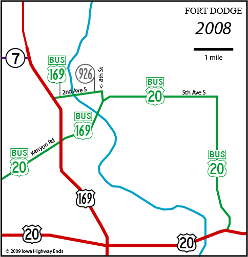
| November 4, 2014: IA 926 turned over to city of
Fort Dodge, except bridges 2014-15: Roundabout project removes block of Business 169 between S 5th and S 6th streets, redirects business route onto two blocks of 1st Avenue S plus one block of S 8th Street |
Page created 5/27/09; last updated 9/2/20