Dubuque Highway Chronology

This page chronicles the highway evolution in the city of Dubuque. In the interest of space for detail, the maps concentrate on the downtown and north-of-downtown area. The listings are more expansive. The red through line is US 61 (and, later, US 151), the green line is US 20, and the purple line(s) after the 1930s is the part carrying IA 3 (and US 52, of course). Dates come from Iowa Highway Commission minutes (before 1950), Iowa DOT online route logs, state highway maps, Jason Hancock's research, and news stories from the Dubuque Telegraph Herald and others.

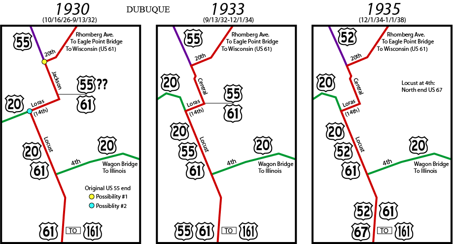
In the original 1920 highway system, the north-south road was IA 20 and the east-west road was IA 5. A road to Cedar Rapids was IA 28, which likely went to the Eagle Point Bridge into Wisconsin to meet the recently designated WI 28. When the US highway system was completely signed in Iowa by October 16, 1926, the north-south road became US 61 south of Dubuque and US 55 north of Dubuque. It is possible that for a short time, US 55 was signed as US 53. We don't know if it ended at its intersection with US 61 or was carried down to the east-west road, now US 20, though it's very likely. The north end of US 161 is confirmed in the village of Key West, south of Dubuque.

US 20, W-E (present-day names): Olde Highway Road, Dodge Street, Crescent Ridge, Cedar Cross Road, University Avenue, Loras Boulevard, Locust Street, 4th Street, Wagon Bridge
US 61, S-N (present-day names): Key West Drive, Rockdale Road, Locust Street, 14th Street, Jackson Street (pre-1932)/Central Avenue (post-1932), 20th Street, Rhomberg Avenue, Eagle Point Bridge

September 13, 1932: US 61 moved from Jackson to Central between 14th and 32nd streets; US 20 moved off 14th/Loras west of Locust to use more northerly alignment (see below)
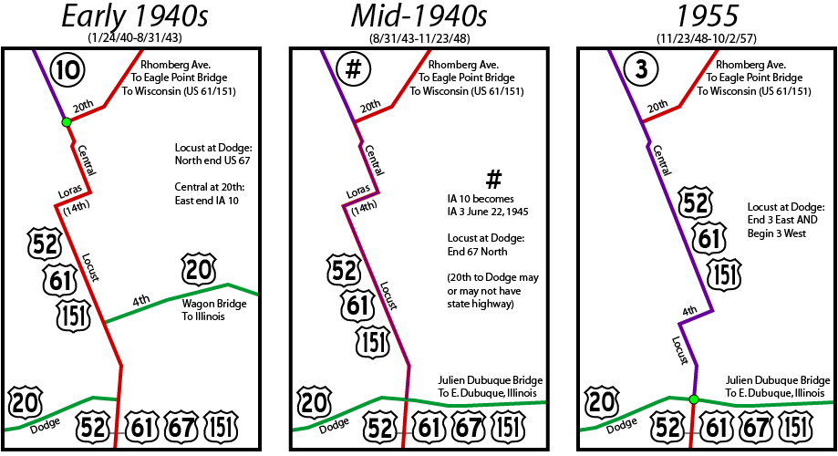
Summer 1932: US 55 constructed between Dubuque and Davenport
February 15, 1935 (approved December 1, 1934): US 55 renumbered US 52; US 67 extended north to Dubuque
November 29, 1939: IA 10 extended east from Luxemburg to Dubuque

US 20, W-E (present-day names): Olde Highway Road, Dodge Street, Crescent Ridge, Cedar Cross Road, University Avenue, Asbury Road, St. Ambrose Street, Clarke Drive, West Locust Street, Loras Boulevard

January 24, 1940 (construction in 1939): US 20 moved onto Dodge Street west of Locust
August 31, 1943: Julien Dubuque Bridge opens
June 22, 1945: IA 10 renumbered IA 3. A large book of hand-drawn maps in the DOT archives unambiguously marks the original end as Central at 20th (US 61), but June 20 Telegraph-Herald article "Highway 10 number changed to Three" says the route ended at "the lower high bridge". That doesn't make sense since the bridge was demolished shortly after the new one opened. The number change merited three paragraphs on Page 2, no competition with "Hitler killed self, chaffeur says".
November 23, 1948: Connecting street between Locust and Central moved from 14th to 4th. The east end of IA 3 was set at US 20 no later than this.
October 2, 1957: One-way system implemented for US 52/61/151. A four-lane segment for US 61/151 from Grandview Avenue to the intersection of Key West Road and Military Road (the south 61/151 split) opened around this time as well.

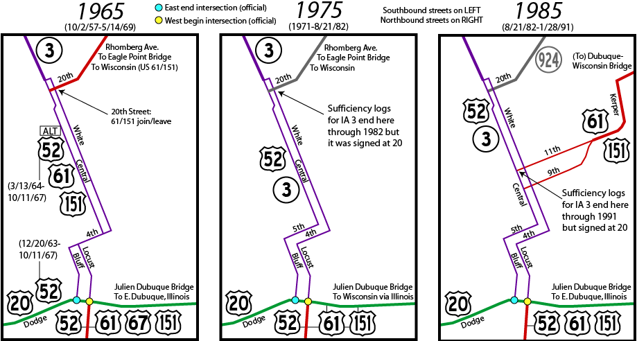
August 31, 1959: New route for 20 opens between the west end of Dubuque and Dyersville; old route becomes IA 416
November 20, 1963: US 52 rerouted onto IA 136 and US 20 between Luxemburg and Dubuque, via Dyersville
March 13, 1964: "Alternate US 52" designated on old route, but this never appears on state maps
October 11, 1967: US 52 moved back to northern alignment
January 24, 1968: US 67 truncated to Sabula, pulled out of Dubuque County
May 14, 1969: US 61/151 rerouted onto US 20 and IL 35 to reach Wisconsin
1971: Fourth Street becomes one-way northeastbound, with southwestbound traffic moved to Fifth
December 10, 1971: New four-lane 151 opens north of Dubuque airport; old road becomes IA 963
August 21, 1982: Dubuque-Wisconsin Bridge opens, restoring direct 61/151 connection
Late 1982: Eagle Point Bridge demolished
January 28, 1991: 1½-mile US 52/61/151 expressway segment from Grandview Avenue to 4th Street in Dubuque opens
December 26, 1991: 2-mile freeway segment from 11th Street to the Dubuque-Wisconsin Bridge opens to southbound traffic; it would open to northbound traffic on August 25, 1992.

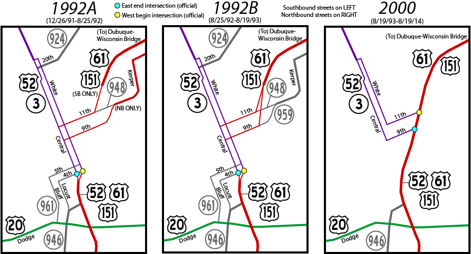
August 19, 1993: Last piece of the 52/61/151 Dubuque freeway/expressway, the ½-mile segment from 4th Street to 11th Street, opens
November 7, 1996: Grandview Avenue and Bryant Street interchanges with 20 open
July 1, 2003: IA 955 and 963 decommissioned
August 19, 2014: Ninth and 11th streets converted to two-way. The mainline for US 52/IA 3 is considered to be Ninth, but 11th remains partially under state control in order to keep a connection for southbound US 61 to northbound 52. ("Dubuque converting one-way streets to two-way", KWWL, Aug. 19)
August 17, 2020: Southwest Arterial opens, rerouting 52 and creating wrong-way multiplex
Spring 2021, date unknown: IA 32 decommissioned

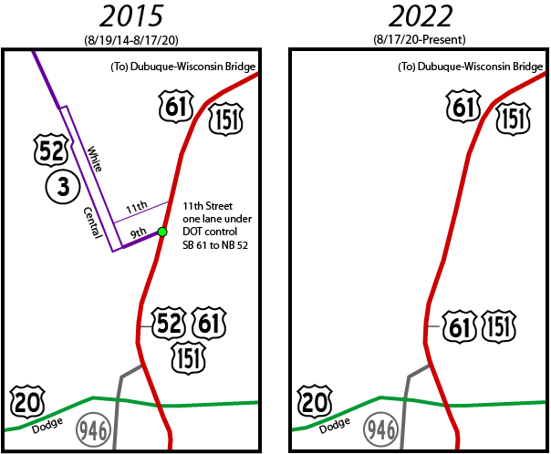
Now that the Southwest Arterial has opened, the only state-maintained surface streets are IA 946 (the connector between US 20 and 61/151) and the at-grade part of 61/151 that goes under US 20.

Page created 4/12/18; last updated 6/1/21

To Iowa Highway Ends Annex

To Iowa Highway Ends Index