 BUSINESS
The segment of old 75/Business 75 from IA 3 north to the north end is IA 404, a designation applied to various bypassed parts of IA 60 as the expressway was built. Why this number was selected (especially since it had just been a real highway, a spur to Montrose), I do not know.
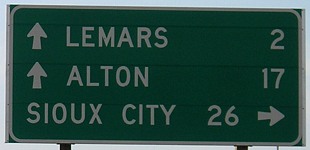
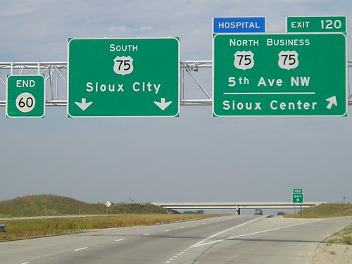
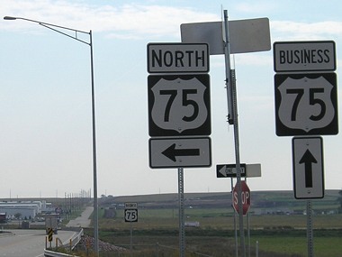
NORTH End: Interchange, US 75 and IA 60, near Le Mars, Plymouth County
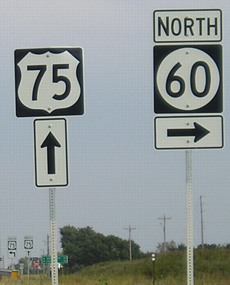
Facing north on Business 75 (widen browser window to see side-by-side) (9/17/07)
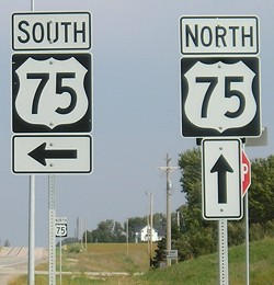
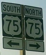
The omission of any direction above the leftmost 75 shield is technically correct, since both northbound and southbound 75 are ahead until after crossing the bridge (right). No "End" signage is present.
Facing south on 75 (9/17/07)
Just south of here is the old end of IA 60, but that intersection has been changed to a plain T intersection. In addition, south of here Business 75 is a three-lane road instead of four.

Facing south on 75 (7/1/07)
Photo by Jason Hancock
Facing north on 75 (7/1/07)
Photo by Jason Hancock
The four-lane has not become IA 60 yet, but similar pull-through signs are now common in the state because many four-lanes change numbers. Here, US 75 will be exiting from itself.
Facing east, but heading north, on 75 (7/1/07)
Photo by Jason Hancock
Not only does 75 exit from itself, it exits using wildly incorrect exit numbers. When 75 was rerouted into eastern Nebraska in 1984, having been supplanted in western Iowa by I-29, the mile markers were never changed. This became evident in a big way in the 2000s, when the Sioux City and Le Mars bypasses opened. Suddenly, the Business 20 exit in Sioux City was exit 4 northbound, but exit 93 southbound, even though 75 only had four Iowa miles left. I suspect the wholesale remarking of the route in Iowa was not done for reasons related to record-keeping, even though the change seems substantial enough to be worth it. (After all, they did it for IA 149.)
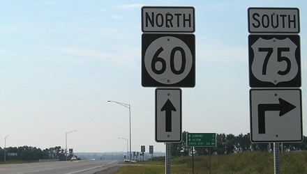
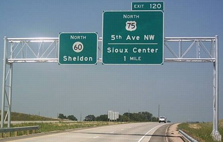
Facing south on 60 (9/17/07)
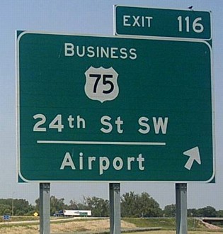
It's rare that the business route and a direction of the main route are on the same BGS for the same exit.
Facing west, but heading south, on 60 (9/17/07)
The Le Mars bypass may be the last new segment of road in Iowa to open without signs in the Clearview font.
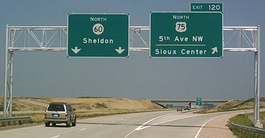
Facing west on the offramp (7/1/07)
Photo by Jason Hancock
Because the exit from 60 opened before the rest of the bypass, this sign set needs to be updated with a "Business" on the left instead of "South".
Can you tell me how to get, how to get to Plymouth Street Le Mars?
Facing north on 75 (9/17/07)
<rant>
During the construction of the interstate highway system and through to the 1990s, when cities got more than one exit, the signs reflected that by telling travelers of more specific destinations - city streets. Thus, the two exits for Davenport on I-80 are listed as Northwest Boulevard and Brady Street, not "Davenport"; the three exits for Waterloo on US 20 (besides I-380) are listed with the street names of Sergeant Road, Ansborough Avenue, and Hawkeye Road. The advance signs warning "[City] Next [X] Exits/Interchanges" were considered enough to suffice.
Until they weren't.
- The US 65 exit on US 18 signed as "Federal Ave" was replaced with "Downtown Mason City" two years after the US 18 bypass of Mason City opened. (In fairness, I should point out that no exit on 18 is inside the city limits.)
- Similarly, the IA 14 exit on US 30 went from "S Center St" to "Marshalltown Business District" within a few years of its opening.
- In 2005, 15 years after the US 20 bypass of Fort Dodge opened, the city decided it had to get on the main signs at the US 169 and east Business 20 interchanges.
- On the other extreme, also in 2005, within ten months after the US 151 bypass of Monticello opened, the X34 exit went from "Main St" to "Monticello".
- Bucking the trend (so far): Maquoketa, which is content to be a "big" city and has had its exits signed as "S Main St" and "Platt St" since 1999.
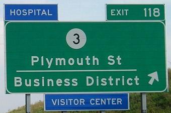
Which brings me to Le Mars, and the sign seen above. Within seven weeks(!) of the bypass' opening, the city requested that at least two of the three new interchanges carry the city name.
After travelers have seen signs for miles giving the distance to Le Mars, and a sign that says "Le Mars Next 3 Exits," and a sign showing a business route, are they really going to be unaware that the town is there if it's not explicitly listed? Often, replacing the sign in the middle of the bypass makes for an odd redundancy - now it will say "Le Mars / Business District", just like how the IA 92 bypass of Knoxville puts "Knoxville / Chariton" on the main sign for IA 14 and then "Business District" on a separate sign - in between the exits for the signed business route. That's what the business route is for in the first place!
And if the exit list can't be settled before the signs are ordered and put up, try going five or ten years with the street names and seeing if there are any actual problems. At least Fort Dodge let the signs age a bit.
</rant>
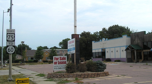
SOUTH End of IA 404: Stoplight, IA 3/Plymouth St., Le Mars, Plymouth County
Facing north on 75, pre-bypass (6/15/04)
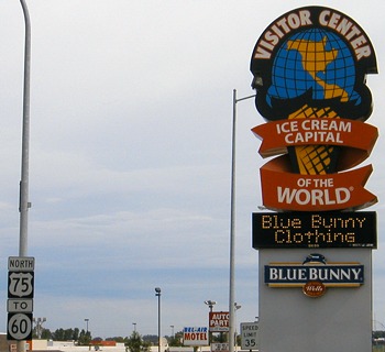
On November 26, 2007, the DOT officially gave Le Mars the south segment of the business route. The piece to the north of IA 3, though, remains under state control. Eventually, the number was revealed: the apparently randomly selected 404, the same number given to all bypassed segments of IA 60. The intersection is right by the Wells Blue Bunny Visitor Center UPDATE: The intersection didn't move, but the visitor center did:
Post-bypass (7/21/12)
Wells Blue Bunny built custom buildings at a prime location...then abandoned them after less than a decade to move to the old Le Mars business district on Central Avenue. Go figure.
An old file in the DOT's archives shows a map of Le Mars where US 75 originally did not run on all of what is now the business alignment. Coming up from the south, at Plymouth Street, 75 went east on Plymouth and then north on 2nd Avenue NW, angling northwest to cross the Floyd River and meet the north-south alignment about 3/8 of a mile south of the old IA 33/60 intersection. This was changed by the 1930s, and the road (5th Avenue NW) north of Plymouth was upgraded to four lanes in 1957. In addition, the Hawkeye Highway in the 1910s was on the east side of the railroad, coming in from Merrill on Lincoln Avenue and using Lincoln Street, 4th Street SW, Central Avenue and possibly Lincoln Street again to get to Plymouth.
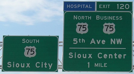
SOUTH End: Interchange, US 75, Le Mars, Plymouth County
Facing south on Business 75 (9/17/07)
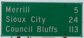
This is the first sign to mention Council Bluffs, a city that US 75 no longer serves.

Facing west, but heading south, on Business 75 (9/17/07)
The last portion of the business route is on a road that serves Wells Dairy's new corporate headquarters. No "End" signage is present.
Facing east, but heading north, on Business 75 (9/17/07)
The bypass construction abandoned a short piece of four-lane entering Le Mars; aerial photos show that the southbound bridge was kept in place but the pavement itself was removed.
Facing north on 75 (7/1/07)
Photo by Jason Hancock
Facing north on 75 (7/1/07)
Photo by Jason Hancock

Facing south on 75 (9/17/07)
Page created 12/18/07; last updated 2/19/14