
(August 4, 1981-July 1, 2003)
WEST End: Tama/Benton county line
EAST End: Stop sign, IA 21, near Belle Plaine, Benton County
These ends are so close to each other we might as well take them as one unit:
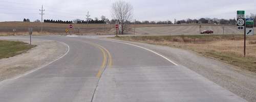
Facing east (11/29/02)
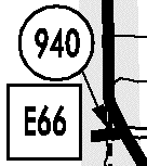
This is the entire route of Iowa Highway 940. Until May 27, 1980, it was part of IA 212, which was extended along this road October 26, 1937, with the straightening of US 30. On that day in 1980, the Tama County Board of Supervisors played (most of) its part in the Great Decommissioning, taking charge of two spurs, 135 and 318, and truncating another, 212, although signs would not change until summer. (The headline of the Traer Star-Clipper that week did not mention IA 171, which may mean it was turned over at a different time.) About a year later, 212 was removed through Belle Plaine to include only its standalone segment, and that's when 940 came into being, because Benton County didn't take action on this 422 feet inside its jurisdiction.
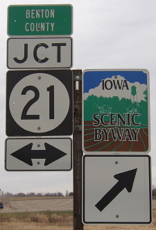
Closeup of signage at right (11/29/02)
At this intersection, 21 is in a curve and just north of here will begin to straddle the Tama/Benton line. Northbound traffic is in Benton County; southbound is in Tama. Tama County may maintain it because a) the signs for V37 north of Dysart, which also straddles the line, have Tama County on them; and b) at junctions with county roads that do not continue into Tama County, there are only LGSs and no blue shields. (Example: E22 west of Garrison.)
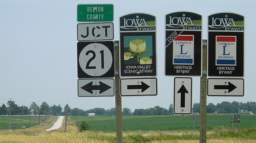
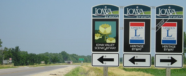
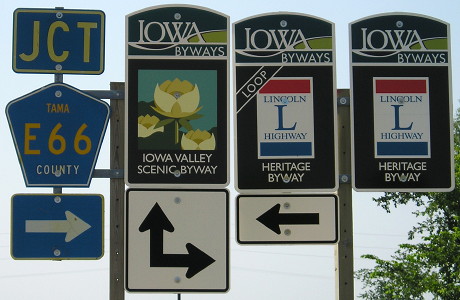
To be more accurate, and also to match the Scenic Byway arrow, the arrows under 21 could be left and diagonal-up right, an arrow type that does exist, because it's at the west junction of US 69 and IA 3 in Wright County. But after the addition of the Lincoln Highway Heritage Byway, here's what that looks like now:
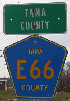
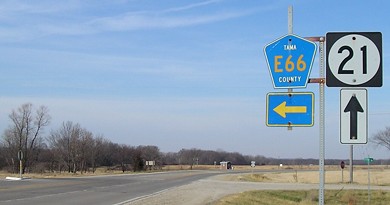
Facing east on 940/E66 (7/7/13)
The earliest route of the Lincoln Highway went straight ahead from the end of 940, and today is signed as a loop route. (The road has since been reconstructed to perpendicularly end at 21.) The Lincoln Highway came into Belle Plaine from the north, turning at 7th Avenue (avenues run north-south), then at 19th Street (streets run east-west), then at 8th Avenue, and then at the intersection of 8th Avenue and 13th Street it turned east on what until 2001 was IA 131. Later on it was shifted to the more-known route that incorporates modern 21. The George Preston Station, originally at the corner of 7th Avenue and 19th Street, moved to the corner of 4th Avenue and 13th Street. For more Lincoln Highway pictures, including the Preston Station, visit my Lincoln Highway Photo Gallery.
Facing west (11/29/02) (green marker has since been removed)
Facing north on 21 (11/22/06)
Because it's so close, 21 has signs for E66, and the intersection has a left-turn lane for northbound traffic as a reminder of when this was a major route. (And it's still the shortest way from Tama to Marengo.) Although generally north of Tama County Road E64, old 212 was probably given the E66 designation because of Benton County's E66 continuing east where 131 turns north. After IA 131's decommissioning, Tama and Benton E66 are 1.25 miles apart, but there are no E66 signs in Belle Plaine.
Facing north on 21 (7/7/13)
Facing north on 21 (7/7/13)
Facing south on 21 (7/6/13)
Facing south on 21 (11/22/06)
Last seen (sort of): 2003 (Benton County map)
Page created 1/24/03; last updated 3/26/17