
(May 12, 1981-July 1, 2003)
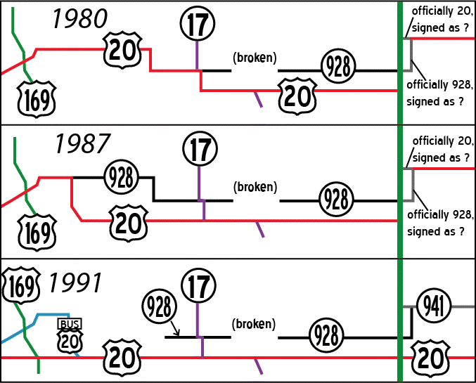
Termini below are marked to its 2003 status. A map showing the extents of 928 in 1980, 1987, and 1991 can be seen here.
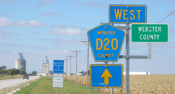
Old WEST End (1987-88): Stoplight, US 20 and P59, Webster County
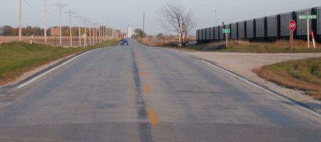
Facing east on 928 (5/7/03)
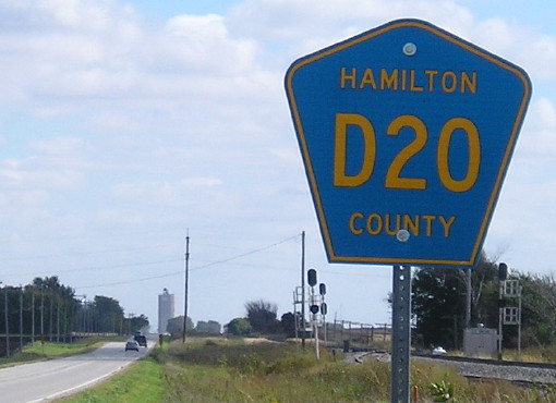
In 1987, US 20 was shifted onto its new freeway segment between IA 17 and P59, removing the small duplex with IA 17. For one year, the route eastward from P59, with the exception of inside Webster City, was 928. The year after, Webster County took its portion of the route and signed it as D20 eastward to the intersection with P71. East of there, past Duncombe to Webster City, the D20 designation continues but east of Webster City it's D25 because Hamilton County already had a D20 to the north. While only active for one year, mile markers for IA 928 reflect this terminus point; MM 11 is the first in Hamilton County.
Facing east on 20, now Business 20 (5/7/03)
Facing east on 20, now Business 20 (5/7/03)
Between 1987 and 1990, 20 itself approached this intersection and turned right; now Business 20 follows that alignment.
At the intersection (5/7/03)
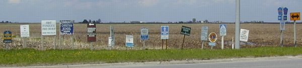
The churches of Fort Dodge welcome you.
WEST End: Webster/Hamilton county line
Facing east on 928 (10/11/02)
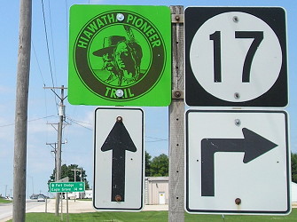
MM 11 is near where the car is. Other portions of US 20 west of 928's farthest west end were turned over to the city, became IA 926 (where it overlaps with current Business US 169), and became the third IA 934 (the diagonal segment west of 169). The highway here follows the survey correction line, one of the lines in Iowa where the counties shift over. In fact, it's the same correction line that goes through Correctionville to the west. Since the square-mile blocks don't line up, neither do the county roads. This picture is taken where the gravel road on the north side stops; notice the pavement change. Because the roads are offset, the county signs are perhaps farther apart than they would normally be. It is apparent that Hamilton County gets the "benefit of the doubt" because this is the west side of the east-west portion of the county line; the train is in Webster County. The white tower in the background belongs to a large elevator at the intersection with IA 17.
And here are said shields; as you can see above there is no designation underneath, customary of secret state routes. (10/11/02) At the time, there were no county road shields because 928 was still active in Hamilton County. This has changed, below.
Facing west on 928 (10/3/16)
These pictures show that the Duncombe and Highland elevators are visible from the county line.
Facing east on 928 (10/3/16)
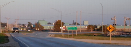
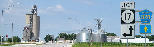
Surrounding area information: Shared segment with IA 17
Facing east on 928 (10/11/02)
The LGS was put up in 1996, indicative of DOT jurisdiction of the road. There's a slight hill here; otherwise I could show you the entire shared half-mile. You can see it all in the next pictures.
Facing west on 17/928 (7/6/11)
Old WEST End (1981-87): T intersection, IA 17, Hamilton County
Facing east, nearly the same spot as the above picture (10/11/02)
Before construction of the US 20 freeway, 17 stayed with 20 for five more miles into Webster City. Now it goes south on what was R21 to join the freeway and regain its old route on the south side of Webster City, at an interchange with a Kmart and McDonald's. Before 1987, the west end of 928 was on the other side of this intersection, behind where the truck is.
Facing west on 928 (7/6/11)
This was where the 928 designation ended before the US 20 four-lane was extended westward. At that time, 20 would have been ahead and left with 17.
Facing north on 17 (7/6/11)
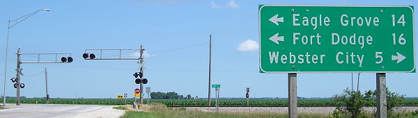
Notice that between the intersections, the distance to Fort Dodge changes but the distance to Eagle Grove doesn't.
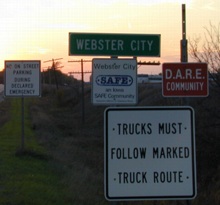
WEST break: City limits of Webster City, Hamilton County
Facing east on 928; note pavement change (5/7/03)
Contrary to what Rand McNally said in the atlas until the late 2000s, IA 17 does NOT follow its original route with old 20 into Webster City. In fact, if heavy traffic tried to follow it they would not be allowed. Webster City took possession of old 20 as soon as the bypass was completed and has reconstructed it from four lanes into two with angle parking. There are also brick crosswalks. The truck route goes around this central business district. Jason Hancock's research indicates that Webster City took its portion of old 20 before the switching of designations in the official logs - the freeway was switched from 520 to 20 and (old) 20 to 928.
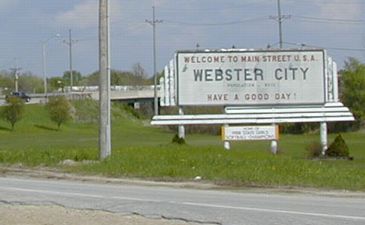
The road in both the foreground and background is old 20; the curve is to the left of this crop. While perhaps US 20 fits the "Main Street USA" title better because it crosses the USA and runs near the middle of it, usually US 66 is referred to as such. (5/7/03)
EAST break: City limits of Webster City, Hamilton County
Facing east (5/7/03)
Still up just outside of Webster City in 2003, but probably gone given pavement reconstruction and a sidewalk extension, was this LGS. While I thought I was back on 928, the city limits sign is about half a mile ahead yet. Behind me is a billboard for radio station KQWC, 1570 AM/95.7 FM, on the air since Feb. 9, 1950.
Facing west (5/7/03)
The car is transitioning from 928 to Webster City jurisdiction. You can sort of make out the pavement change.
Signs on right side of above picture (10/11/02)
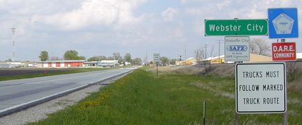
The warning at the bottom is because "trucks" are not permitted on what used to be 20.
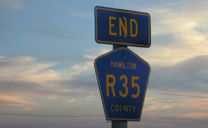
Facing south (10/11/02)
The Webster City city limits are right at the intersection with R35. There was a nice sunset in the background (sorry I can't show you more).
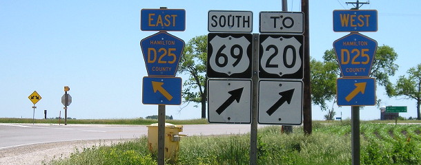
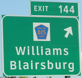
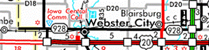
Junction US 69 (Blairsburg)
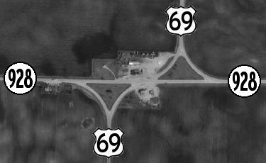
(USDA NRCS/MIT via ortho.gis.iastate.edu)
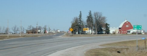
Facing east on 928 (10/11/02)
As we work our way east, this is the first sign (no pun intended) that this road was once a major highway, and this was once a major intersection. This intersection also explains why the line for US 69 on the map shifts over slightly, and the map changed 69's line from red to black here until 2003.
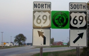
Facing south on 69 (5/31/11)
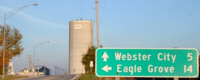
At far right is an LGS pointing to Jewell and Webster City.
NOT an EAST End: I-35 exit 144, Hamilton County
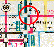
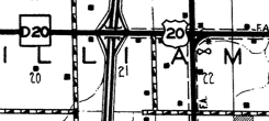
In the 1981 route log, the first one to include IA 928, a surprising thing pops up. It's further corroborated in the national 1989 log of US highways. It seems that, despite what state maps indicated, the official routing of US 20 joined I-35 between exits 147 (D20) and 142 (the cloverleaf). The north-south road through Williams was officially IA 928. Now, signage in the field in the '80s is unknown, although there are some theories below. The net impact of having 928 run through Williams is that it enabled the short connecting segment between I-35 exit 147 and the east end of 928, circled in the 1986 state map clip at left and shown in the 1986 Hamilton County map at right, to be catalogued as US 20.
Facing east on 928 (12/8/02 and 7/6/11)
The US 20 segment between I-35 and US 69 had been complete since 1968. However, the US 20 segment between I-35 and US 65 was not first built until 1991. For eight years the cloverleaf of 35 and 20 was a cloverleaf near the middle of nowhere. Until 1975, 35 ended just north of the cloverleaf and until a year later, the only freeway segment of 20 was the 3 miles from there to US 69. In other words, the southbound-related ramps served half a mile of freeway at the cloverleaf's inception and four of the ramps were unused for 23 years.
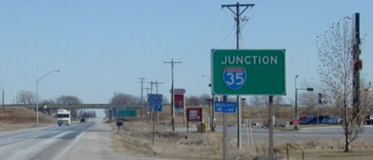
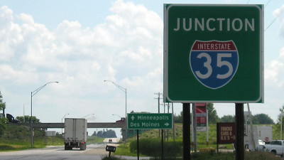
The 2002 sign eastbound shows that you were not on 20 here. Westbound, there was no such sign, only a standard "Jct 35", possibly because 20 was signed on its original route again despite that not being the official record. To the right is a truck stop and cafe that had a full parking lot when I went by. The place, formerly Trump's Restaurant (really), was transformed into a modern Flying J travel plaza with a Subway in the early 2010s.
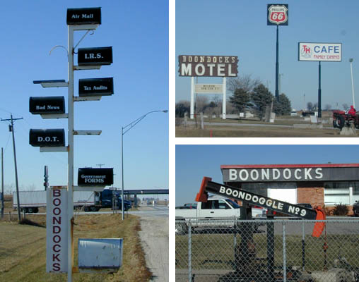
Boondocks, n. 1) Rural country; the backwoods. 2) Famous truck stop at the intersection of I-35 and Old US 20. (12/8/02)
The area has seen better days. The RV campground (or so the signs say) to the left of the mailbox was empty; an abandoned Dairy Queen is there. Half of the gas pumps at the station have been removed (and there were a LOT of them). There's still lodging available, though; there's a Best Western Super 8 (as of late 2018) (although reviews aren't kind). The Boondocks Motel opened May 8, 1978.
By mid-2011 the gas station had lost its Phillips 66 franchise and the mailbox pole was down to four. (7/6/11)
HELP WANTED: Baker, cooks, and
custodian, all shifts. Apply in person, ask for Preston Aust, Boondocks
U.S.A., I 35 and U.S. 20, N.E. corner.
— Webster City Daily Freeman-Journal, June 7, 1973. It does not appear the FJ wrote about the opening. (10/19/18)

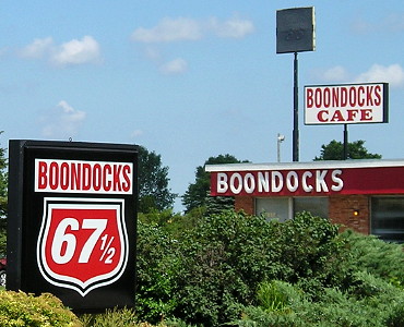
The owners of the Boondocks announced that the truck stop would cease operations October 20, 2018. The Boondocks opened June 5, 1973, when I-35 came to an abrupt stop right here at old 20. It was a truck stop built for the burgeoning interstate era, a restaurant combined with convenience store, gas pumps, and truckers' rest space. Forty-five years later, it was ... a truck stop built for 1973. A Freeman-Journal article in 1988 said a larger restaurant was added in 1976. The only standout indicators inside that wouldn't have fit into 1978 — or 1993, or 2008 — were the widescreen flatscreen TVs, all tuned to an over-the-air channel, and the bumper sticker "Honk if you love Jesus, text if you want to meet him."
Free Pie until all is gone, thank you. "All we have left is pumpkin." That'll do.
"The Boondocks became a legendary venue off Interstate Highway 35, 100 minutes or less from anywhere and nowhere, where Iowans met family members, dropped off kids, or took a road break for a hot beef sandwich." — Des Moines Register, October 13, 2018
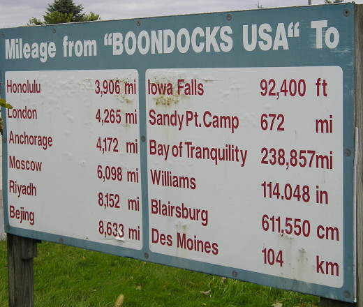
The Williams distance works if the period is turned (or restored?) into a comma. (10/19/18)
Facing north on 35 (12/8/02 and 7/29/10 and 7/6/11)
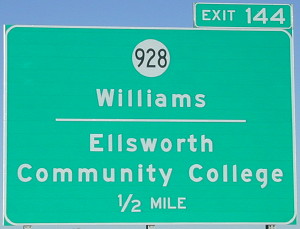
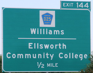
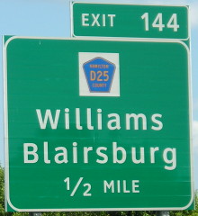
The BGSs on I-35 were the only official signage of IA 928, exactly like 988 in Pottawattamie County. If it wasn't the biggest non-freeway-to-freeway BGS in Iowa, then the honor belongs to Y21 on US 20, listing Northeast Iowa Community College. This BGS is only a half-mile advance because US 20 is just to the south. After 928 was decommissioned, a County Road D25 shield was put on, but between July 2010 and July 2011 a Clearview BGS was put up without Ellsworth CC.
Facing north on 35 (7/6/11)
EAST End: Intersection, IA 941, Hamilton County
At this intersection, the secret designation for old 20's route changes. A diagram, also marking 20:
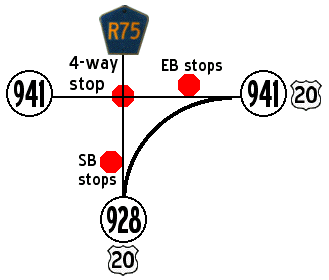
After decommissioning, the curve notwithstanding, Hamilton County made the east-west part all D20 and the north-south part R75.
Facing north, but heading east, on 928 (12/8/02)
I'm not quite sure where the "official" designation would change along the curve from 928 to 941. I would guess the north end.
Facing west on 941 (12/8/02)
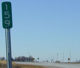
This mile marker remains from US 20, on the actual route. It's the next one, 158, that's strange because it is west of here, not on old 20. However, that makes perfect sense in light of an official routing of 20 directly west of here and onto I-35 in the 1980s (see the map discussion above), and may well have been the only indicator of 20's presence on that road.
Facing east on 941 (12/8/02)
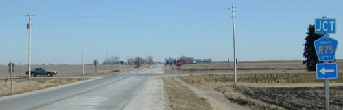
Turn left for R75. Turn right for 928 southbound/westbound, and you will have a stop sign at the curve. Continue ahead for 941, and you will have a stop sign there as well.
Last seen: 2003
The last year 928 existed was the first year the official state map labeled it.
Page created 12/15/02; last updated 3/21/19