

(1920-September 19, 2003)
- In 1920, they knew it as: "The Middle Ft. Madison to West Point road; also the West Point to Courtright Corner road", according to the Highway Commission minutes of April 15, 1920
- We know it as: Until the Second Great Decommissioning, IA 103, now County Road J20
- Let's get granular: Practically unchanged, although the segment between US 218 and West Point wasn't nearly as smooth/straight.
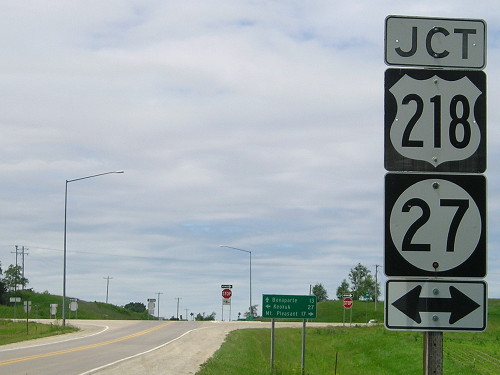
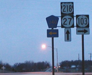
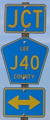
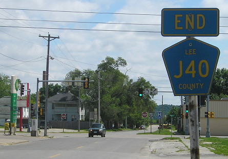
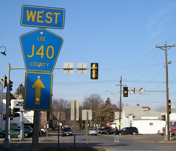
WEST End: US 218/IA 27 and J40, formerly IA 40, Lee County
Facing west on 103 (3/31/02)
Photo by Jason Hancock
Facing west on 103 (6/1/15)
Until construction of the Avenue of the Saints, this intersection was unchanged, probably. The ambiguity in the western part of the route noted at the top of the page is due to the minutes specifically mentioning "Courtright Corner", which might have been a mile and a quarter north, because that's the route highlighted in red in the 1914 county map although it's also marked as "Added 12-22-32". But Courtright is double billed on the map, and requires more explanation:
It is not often than a small
town is honored by having three names, but such is the case with this
one. The original plat was made by James A. Davis, county surveyor, for
A.L. Courtright and R.A. Jarrett and it was filed under the name of
'Courtright' on July 5, 1881. When the postoffice was established there
it was given the name of 'Mount Hamill,' and as a station on the Keokuk
& Mount Pleasant division of the Chicago, Burlington &
Quincy Railroad the name appears on the time tables as 'Hamill.'
— Story of Lee County, Iowa,
by Samuel W. Moorhead (1914)
Strong evidence in support of this intersection being the end of 103, even though the road east to West Point was MUCH less straight than it is now, is how the state maps show IA 40 turning west at the 103 junction and then north, going near the village of Mount Hamill.
Facing west on 103 (4/20/08)
Facing north on 218 (12/30/01)
Facing north on 218/27 (4/20/08)
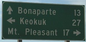
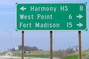
The Harmony school district is nominally of Farmington, but the high school itself is half a mile west of the Lee/Van Buren county line on J40, about six miles north of Farmington. (How will this change now that Harmony no longer has a high school?)
These pictures were not taken in quite the same place as the nighttime picture, because around this intersection, the new four-lane was constructed without using the existing roadbed. A short piece of the old two-lane is in the northwest corner of this intersection as a park-and-ride.
Facing south on 218 / Facing north on 218/27 (ca. 1998 and 4/20/08)
Left photo by Jason Hancock
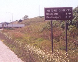
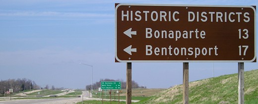
Bentonsport is one of the Villages of Van Buren, and has the distinction of being the only town printed in red on the state map.
Originally, IA 103 was not scheduled to die in the Second Great Decommissioning, but Lee County was spared a worse fate - an IA 16 between US 218 and US 61 badly in need of repair. In an exchange decided in mid-2003, the whole of 103 was turned over while 16 was spared. I think it makes a little more sense in the greater scheme of things, anyway, since 16 is more equidistant between US 34 and IA 2 between 218 and 61.
But judging by the street sign, Lee County apparently wasn't quite sure what to do with the road naming-wise. The blue pentagons say J40, but the E911 markers don't. (Locals may keep referring to it as Highway 103 for the next 30 years. We'll see.)
Facing east on 103 (6/1/15)
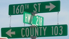
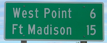
Lee County has a unique practice of posting mileage signs after intersections.
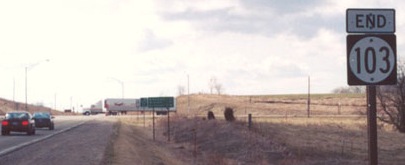
*Original Number, Original End* (intersection obliterated in 2005-06)
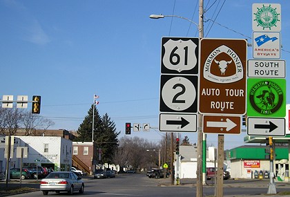
EAST End: Stoplight, US 61/IA 2/Avenue H (IA 20 in 1920, now Business US 61), Fort Madison, Lee County
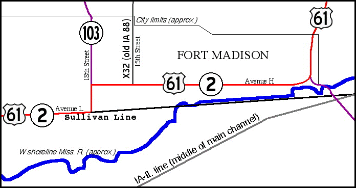
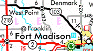
This map doesn't show part of the one-way pair of 61 and 2 west of 18th Street, but all else is to scale. This is the easternmost extent of the Sullivan Line, a line intended to demarcate the Iowa-Missouri border (west of the Des Moines River) and the Half-Breed Tract (south of the line) in the 1810s. Unfortunately, Sullivan screwed up; the line is not supposed to be anywhere near downtown Fort Madison. In fact, the line migrates northward one mile between the west and east borders of Lee County. Avenue L follows the line, and 61 (now Business 61) and (old) 2 follow it for a while. Just east of 103's end, the line goes in the river and parallels the shoreline for a while. IA 2 crossed into Illinois on the right side of the map. (Map created in 2005.)

Facing south, but heading east, on 103 (3/31/02)
Photo by Jason Hancock
Assuming Avenue H always carried the highway in this section of Fort Madison, this was always 103's end.
Facing south, but heading east, on 103 (6/1/15)

Closer to the intersection (3/31/02)
Photo by Jason Hancock
The backs of signs below can be seen by the "Do Not Enter" sign. The oncoming traffic is northbound on 61/2, but to go south on 61/2, you need to turn right (hence the double arrow).
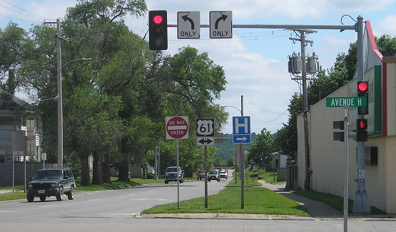
Facing south, but heading east, on 103 (6/1/15)
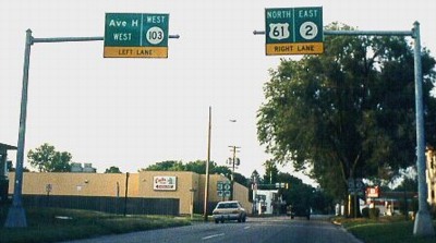
Facing north on 61, but heading east on 2 (pre-decommissioning)
Photo by Mark Roberts (Summer 1998)
Jason Hancock says "Overhead signs in Fort Madison indicate the point where US 61 and IA 2 make a turn eastward (again) after about two blocks running north-south." There are also shields on the sides of the road. Southbound traffic uses 21st Street, three blocks west. After IA 103 was decommissioned, the overhead signs changed.
Replacements for above signs (post-decommissioning) (12/18/06)
The sign on the right has been removed since the US 61 bypass opened and IA 2 was decommissioned.
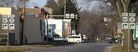
Facing north on 61, but heading east on 2 (12/18/06)
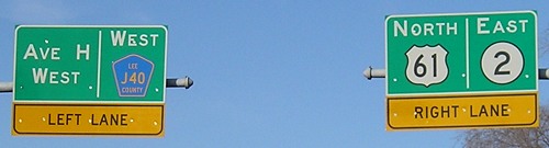
Sign on left side of 18th Street at intersection (12/18/06)
Sign on right side of 18th Street at intersection (12/18/06)
Last seen: 2003
Page created 12/12/01; last updated 5/22/20